Digitaler Zwilling
Digital Twins for Regions: Why Cross-Municipal Data Platforms are gaining Importance
Digital twins are no longer just a topic for large cities. Regions are also increasingly creating digital representations of their infrastructure to connect data, make more informed decisions, and strengthen collaboration across municipal boundaries.
Mobility, climate adaptation, energy supply, land use management, or disaster preparedness—many of these challenges do not stop at municipal boundaries. They require a regional perspective.
Rhein-Kreis Neuss: Digital Twin as a Regional Data Platform
The Rhein-Kreis Neuss demonstrates what such an approach looks like in practice. Together with its eight member municipalities, the district has developed a digital twin. The platform brings together 3D city models, geodata, aerial photographs, 360-degree images, and other spatial information, and makes them publicly available via VC Map. For this project, the district won second place in the “Districts, Ministries, and Other Government Agencies” category at the 2025 Digital Award.
The Rhein-Kreis Neuss is not alone in this endeavor: Other regions are now also turning to digital twins as a shared infrastructure for districts and intermunicipal associations—we present two additional examples below.
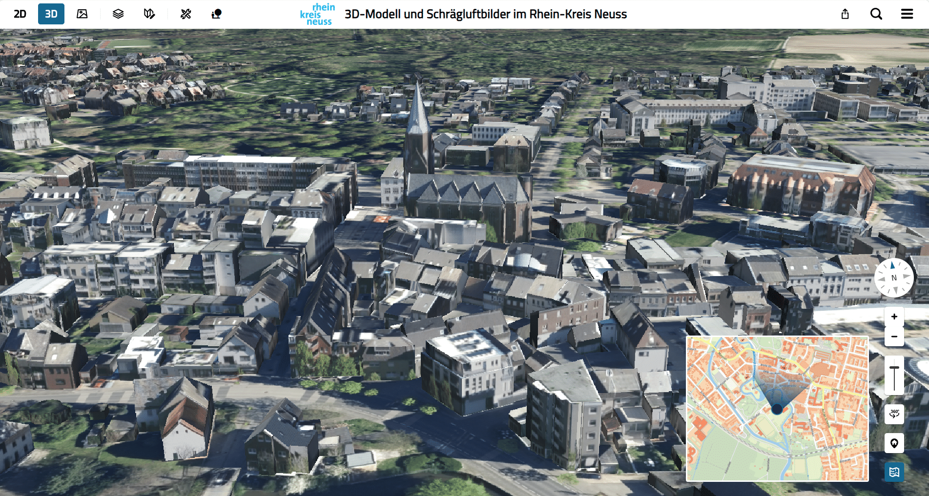
A digital view of reality: The 3D city model of Rhein-Kreis Neuss brings buildings and urban structures to life in three dimensions.
From Geodata to a Common Basis for Decision-Making
Many government agencies have extensive data sets—but these are often scattered across individual departments, which have little ability to access them across departmental boundaries.
A digital twin bridges this gap: It reveals connections between land use, transportation planning, and climate adaptation—and enables decisions to be made based on a broader data set.
Why Regions benefit in Particular
County-level authorities often play a coordinating role between cities and municipalities, while many issues affect the entire region. Digital twins help consolidate data sets across municipal boundaries, highlight regional developments, and better coordinate planning processes among the participating municipalities.
At the county level, this creates a digital situational overview—a consolidated, up-to-date summary of spatial and infrastructural developments—that extends beyond individual administrative boundaries.
More than just visualization
A digital twin requires more than just an interface for displaying geodata. What is crucial are reliable processes that local governments use to prepare, update, make available, and manage data. These include:
- the processing and publication of 3D geodata,
- the regular updating of data sets,
- hosting and operational models for large volumes of data,
- open interfaces for connecting to existing systems.
Only when these processes work together reliably can a one-time data export become a permanently usable digital twin that continues to provide up-to-date information even years later.
The technical foundation for long-term operation
This is exactly where our solutions come in: Virtual City Systems supports municipalities, counties, and regions throughout this entire lifecycle. With VC Publisher, government agencies can process and publish 3D geodata for web distribution. VC Map serves as a browser-based application for visualization, analysis, and cross-disciplinary data access.
Thanks to open standards, existing geodata infrastructures and specialized processes can still be integrated—there’s no need to start from scratch.
Would you like to know what a digital twin might look like for your county or region? We’d be happy to advise you on its development, operation, and ongoing maintenance.
From the Data Platform to the Smart Region
Building on this, digital twins become tools for:
- data-driven analyses and the evaluation of planning scenarios,
- the integration of sensor data into monitoring and situational awareness systems,
- participatory processes, and intermunicipal cooperation.
The Rhein-Kreis Neuss serves as an exemplary model of how counties and municipalities can jointly establish digital infrastructure—and how individual geodata sets, combined with powerful processes, reliable delivery, and accessible tools, can give rise to a Digital Twin that is sustainable in the long term.
Digital Twins in Action: Three More Examples
Elsewhere, too, we see how digital twins are making an impact at the state and county levels:
Baden-Württemberg in 3D
With “Baden-Württemberg in 3D,” the LGL Baden-Württemberg operates a statewide digital twin featuring official 3D geodata and specialized information. A key feature is the proven planning tool proven as part of the Smart Villages project: Users can integrate their own 3D models and BIM objects or use an integrated object library to create and visualize planning scenarios directly in the 3D environment. The published plans can be viewed on the “Planning and Construction” thematic map.
[Read the article: Baden-Württemberg in 3D: LGL Web Application Launches with New Content and Features]
Saarland Digital Twin
Since March 2026, Saarland has been making geodata publicly available—from point clouds and 3D data to risk maps for flooding and heavy rain. Implemented in collaboration with our partner M.O.S.S. and using VC Map as the mapping platform.
[Read the article: Saarland Digital Twin: Open Geodata and Strong Partnerships]
Hof District
With hoferLand.digital, the Hof District has built an entire system landscape comprising VC Map, the CIVORA smart city platform, and locally collected geodata—including an “Innovation Space” featuring VR applications, sensors, and dashboards. All 27 municipalities in the district access the same database.
[Read the article: Digital Future in the District of Hof: How hoferLand.digital is building a New System Landscape]