Urban
Simulation  

Make predictions, identify potential,
and estimate risks.

What if…?

Urban spaces need solid predictions  

Climate change and the increasing growth of cities are posing major challenges to the design of urban spaces. How will a new building affect the flow of wind? What’s the best way to respond if an old aerial bomb is discovered in a densely populated urban area? Where are urban heat islands located, and where does the greatest potential for solar energy lie? These and many other questions now need to be answered to ensure the safety and well-being of citizens in the cities they call home – and to facilitate adjustments to changing climates.

Urban spaces are delicate and complex. This is why they require the best possible predictions in order to identify potential and gauge risks. If an unexploded bomb from a past war is found, for example, how wide will the evacuation radius need to be? Does the nearby hospital need to be evacuated completely, or is it out of harm’s way?

Bomb simulation  

How large is the evacuation radius? Does it include a hospital or nursing home?

Wind simulation

Where are structures causing unwanted wind flows? Pollution levels are measured, but how does it spread?

3D solar potential analysis  

Where does solar energy present the most potential? Where are buildings strongly affected by shade?

VC Blastprotect: Visualization of the splinter flight and the pressure wave in the urban area

Visualization of the splinter flight and the pressure wave in the urban area

Urban simulations based on 3D city models

Along with CADFEM, we’ve been working for many years on solutions for urban simulation. The wide variety of projects we’ve carried out have resulted in technologies that are now serving as a basis for the various interfaces and simulation solutions we provide for 3D city models and detailed building models.

In addition to the products we offer with CADFEM, we’ve begun collaborating with other partners on ways to facilitate urban simulations for the cities of tomorrow.

Our solution for urban simulation combines 3D city models with numerical simulations and analyses. This makes it possible to create and evaluate the results both across the board and for specific locations.

In a given 3D city model, any area can be selected for examination, and urban objects can be added or hidden from view. This is how our solutions enable users to map a wide range of scenarios and compare them with one another.

These city models serve as the basis of each simulation and add value by providing three-dimensional context.

Coupling of 3D city models with
numerical simulations and analyses

Bomb simulation

Our bomb simulation solution simulates the propagation of blast waves and fragments from unexploded ordnance from World War II while factoring in surrounding structures.

By including specific local influences like these, the results of its simulations provide a visual impression of the effects of a potential detonation with unprecedented accuracy and speed. This makes it possible to differentiate among areas exposed to varying levels of risk and significantly improves the planning of defusing, evacuation, and protection efforts.


Simulation of the splinter flight VC Blastprotect

Simulation of the splinter flight

Wind simulation

Simulation windfeld New York

Simulation windfeld New York

Our wind simulation solution is capable of producing comfort studies and simulating the spread of emissions in urban spaces. It can also evaluate factors like wind pressure, velocity, volume flow, and temperature either at specific points or across larger surfaces (such as building facades). By merging solar radiation analyses with wind and thermal simulations, the solution makes it possible to examine heat islands and similar urban phenomena, as well. Thanks to its ability to map the emission and flow of particulate, it can also simulate the spread of harmful substances in urban environments.


3D solar potential analysis

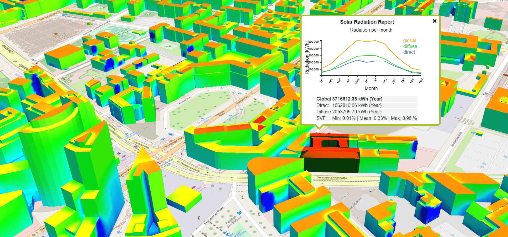
The solar cadasters currently available are two-dimensional and only calculate solar radiation on rooftops. But how can the potential of facade surfaces and shading effects be determined in detail for the evaluation of energy measures in an urban context?

Enter our solution for 3D solar potential analysis, which can produce monthly measurements of direct, diffuse, and global solar irradiation on the roofs and exterior walls of buildings. It even factors in the shade caused by vegetation, other buildings, and other objects on the premises in question. Clicking on a building’s surfaces brings up clearly illustrated charts that make it possible to systematically assess monthly and annual trends for every type of radiation (direct, diffuse, global).


Annual courses of all radiation types for selected object surfaces

Annual courses of all radiation types for selected object surfaces

Products

VC Blastprotect

Physical simulation of detonations to help analyze hazards in three-dimensional space.

VC Publisher

This is how easy building a digital city model can be – with the intuitiveness and performance of VC Publisher.

VC Database

A professional administration system for CityGML data that makes database operations a snap.

VC Map

Visualize, analyze, and simulate 3D city models on the web with this multifunctional, platform-agnostic solution.

Would you like to learn more about our Urban Simulation solution?

Request more information