Arnsberg: The Urban Digital Twin for Climate Adaptation and Sustainable Urban Development
How Arnsberg makes spatial relationships visible and prepares complex topics for administration, infrastructure, and the public in an understandable way
The Urban Digital Twin of the City of Arnsberg:
A Foundation for the Smart City
3D as a Basis for Climate Adaptation, Planning and Public Information
The City of Arnsberg is developing its Urban Digital Twin as a central foundation for digital applications in the areas of climate, planning and public information. The 3D twin was deliberately not designed as a stand-alone application, but as a platform for different use cases: from flood and heavy rainfall simulations to solar potential analysis and the visualization of wind turbines.
At the same time, the Digital Twin complements the city’s existing 2D geoinformation services with a spatial perspective as well as additional analysis and visualization capabilities.

“The Digital Twin helps us to present complex topics in an understandable way and to make information accessible to different target groups.”
Climate goals as a driver of development
The idea of a Digital Twin did not originate solely from Arnsberg’s Smart City strategy. The motivation to build the Digital Twin is also closely linked to the city’s strategic climate goals. Arnsberg is pursuing ambitious targets: the city administration is to be climateneutral by 2030, and the entire city by 2035.
The Urban Digital Twin is intended to help make complex interrelationships visible, to support planning and decision-making processes, and to provide information in a way that is understandable for very different target groups.
Three key applications for climate, energy and urban development
1. Flood and heavy rainfall simulation
A central application area of the Digital Twin of Arnsberg is the simulation of flood and heavy rainfall events. Different scenarios show which areas would be affected by events of varying intensity. This is particularly relevant for Arnsberg, as the Ruhr runs through the city area and has already caused flooding in the past.
The simulations enable citizens to make an initial assessment of possible risks and at the same time support technical planning for risk mitigation within the administration.
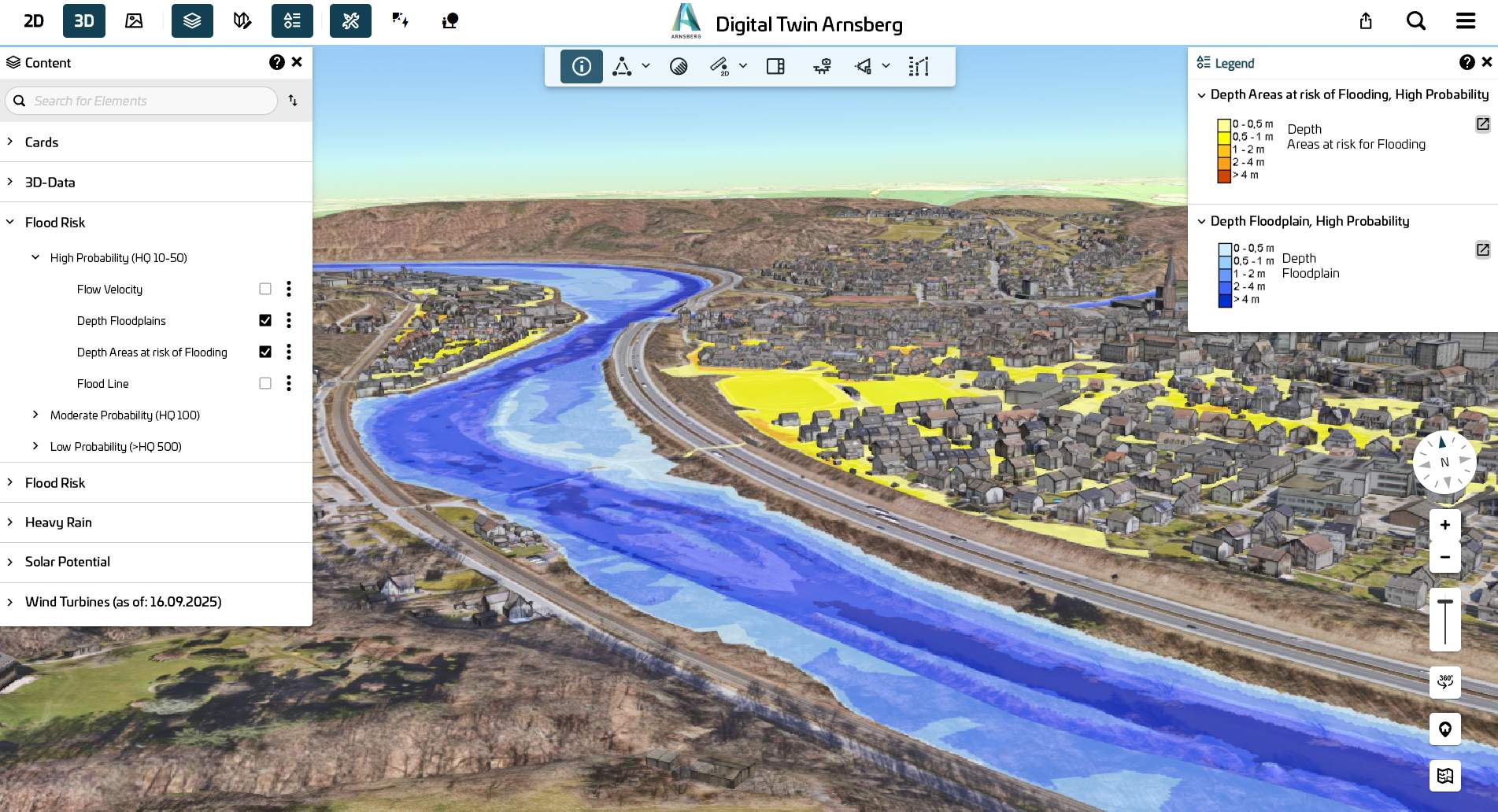
Figure: Flood and heavy rainfall simulation in the Digital Twin – visualization of potentially flooded areas along the Ruhr.
2. Solar potential analysis
Citizens can directly use the 3D model to check whether their own roof areas, balconies or façades are suitable for photovoltaics. An automatically generated report provides information on solar radiation, solar potential and the economic efficiency of the selected areas and serves as a basis for further steps, such as discussions with contractors or energy consultants.
The city involved the consumer advice centre and installation companies at an early stage. Positive feedback from practice confirms the quality of the results.
The possibility of also taking balconies and façades as well as shading from dormers into account significantly extends the analysis beyond traditional roof surfaces.
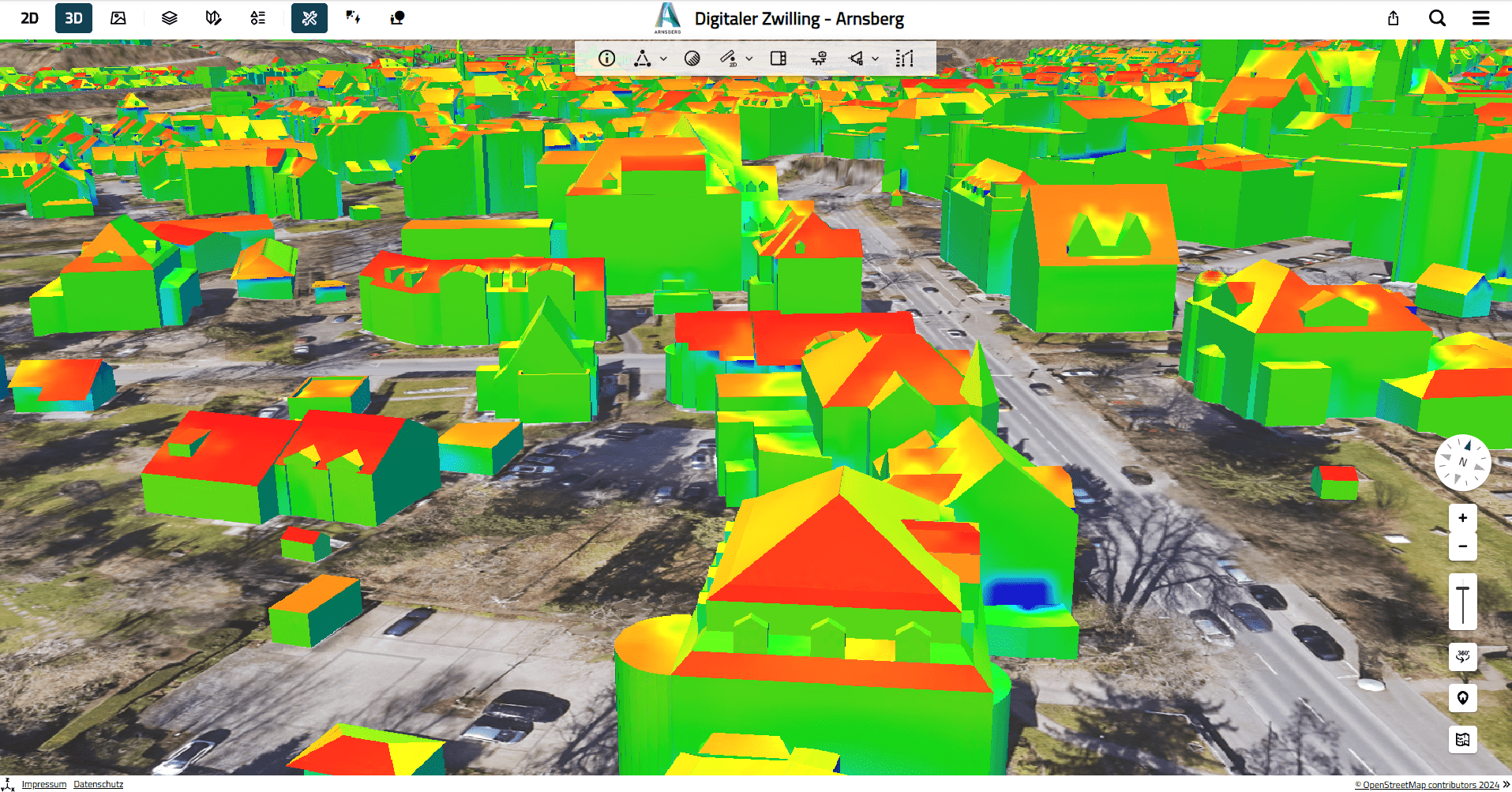
Figure: Solar potential analysis in the 3D model – assessment of the suitability of building surfaces based on solar radiation and shading.
3. Visualization of wind turbines
Wind energy is a relevant and widely discussed topic in Arnsberg. The 3D visualization in the Digital Twin shows planned and existing installations in their actual height and location and enables a realistic assessment of visibility.
In contrast to static representations, this creates a comprehensible image that contributes to a more objective discussion.
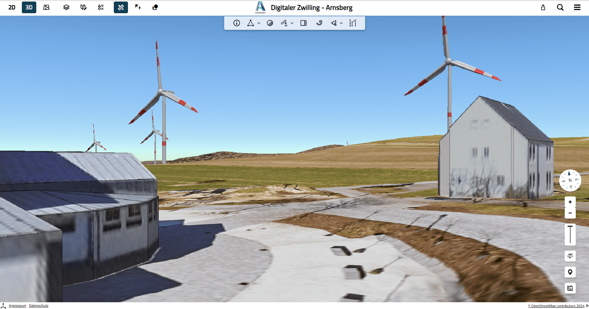
Figure: Visualization of wind turbines in the Digital Twin – realistic assessment of height, location and visual impact in the surrounding area.
The solution: Integrated 3D platform with VCS technology
For the development and operation of the Digital Twin, the City of Arnsberg relies on an integrated solution based on technologies from Virtual City Systems. The following are used, among others:
- VC Map serves as the central 3D visualization interface for citizens and professional users and makes topics such as flooding, solar potential or wind turbines interactively accessible.
- VC Planner supports visualization and professional planning in the 3D city model, for example for flood and heavy rainfall scenarios or other urban planning topics.
- VC Solar provides detailed solar potential analyses including report downloads on solar radiation, yield and economic efficiency of suitable areas.
- VC Publisher enables the provision, maintenance and subsequent independent extension of 3D content by the city administration.
The different components work together seamlessly and enable both internal use within the administration as well as the public provision of selected content. With VC Publisher, content and models can be updated and expanded independently by the city – for example geodata, bridges or other infrastructures.
Concrete benefits for different target groups
The Digital Twin is already actively used by different user groups, each deriving a different benefit for administration, infrastructure stakeholders and the public.
Administration and planning
Departments use the 3D model to support planning processes, to visualize projects and also to quickly determine measurements. Many questions can be clarified directly on the computer, without the need for on-site appointments.
Views and spatial situations from the 3D map can be used as a basis for internal coordination, presentations and participation processes – either via screenshots or directly by viewing the model together.
Utilities and infrastructure
Municipal utilities also use the Digital Twin to digitally pre-check routes, properties and spatial situations. This significantly facilitates the preparation and coordination of infrastructure measures.
Citizens
For citizens, the Digital Twin creates low-threshold access to planning and climate topics. Spatial relationships become transparently understandable and developments in the immediate living environment tangible.
Why 3D makes the difference
The added value of the Digital Twin lies not only in visualization. Its strength lies in the combination of spatial representation and professional analysis. Compared to traditional 2D applications, the 3D environment opens up new possibilities:
- realistic assessment of visibility, heights and distances
- additional analysis options through the spatial representation of buildings and surfaces
- improved comprehensibility for non-expert target groups
The solar potential analysis clearly illustrates the added value of 3D. While traditional 2D applications mainly consider roof surfaces, the 3D representation additionally enables a realistic assessment of buildings, surfaces and shading situations. This results in significantly more precise and realistic evaluations. This makes the Digital Twin a practical tool for administration, business and the public alike.
Smart Cities South Westphalia: Developing digital solutions together
Arnsberg is part of the “5 for South Westphalia” network, established within the federal funding programme “Model Projects Smart Cities”. Together with the cities of Soest, Menden, Olpe and Bad Berleburg, Arnsberg is working on digital solutions for key future challenges.
The Urban Digital Twin plays an important role within this network. It connects climate protection, urban planning and public information on a shared data and visualization basis and creates the foundation for further digital applications. Within the City of Arnsberg, the Smart City team works closely with departments such as GIS and planning, while also being responsible for external communication and knowledge transfer – for example through information services, training and exchange with other municipalities.
Communication and involvement as a success factor
The development of the Digital Twin in Arnsberg was not only a technical but also a communicative project. Questions and differing expectations – and thus the level of interest – from the public made it clear how important transparent communication and early involvement are. The city therefore actively engages in dialogue with citizens as well as with different departments inside and outside the administration.
Information and developments related to the Digital Twin are continuously communicated and contextualized through events, training and other formats. At the same time, internal use of the Digital Twin is being further expanded. Workshops and training support departments in integrating the possibilities of the 3D platform more strongly into existing processes.
Looking ahead: The Digital Twin continues to grow
The Digital Twin in Arnsberg has been designed as a growing system from the outset. New data from a recent aerial survey is currently being integrated. Planned, among other things:
- more realistic representation of vegetation, especially forests
- addition and updating of infrastructure such as bridges
- expansion of independent data maintenance by the administration
- integration of additional specialist information
“The Digital Twin is not a stand-alone project for us, but a foundation that continues to grow – with new applications, additional information and as a tool for data-based and climate-conscious urban development.”
Further develop the Urban Digital Twin for your city
Would you like to use spatial data to make developments within your city easier to understand and communicate complex issues clearly? With the VC Suite, we show you how an Urban Digital Twin can be used as a reliable foundation for analysis and well-informed decision-making.
“The visualization of planned wind turbines is a good example. Especially in sensitive planning topics such as wind energy, an Urban Digital Twin shows its added value: complex spatial relationships become understandable and discussions can be conducted in a more objective way.”