ClimateDigital TwinVC Map
Speyer Digital Twin: Understanding Data, Shaping Climate Resilience
Where do heat islands form? How do additional trees or unpaved areas affect the urban climate? Which areas are particularly at risk during heavy rainfall? Questions like these are increasingly on the minds of local governments. The Speyer Urban Digital Twin compiles relevant information, illustrates its spatial relationships, and supports data-driven planning of measures for climate-resilient urban development.



Working Together for the Speyer Digital Twin
The flagship project for Rhineland-Palatinate is based on the idea of visualizing the city as an interconnected system. Data on climate, the environment, infrastructure, transportation, and urban planning are consolidated on an urban data platform and spatially anchored within the city’s digital model. Selected scenarios can also be experienced in a virtual environment. This provides a comprehensive view of interactions, potential developments, and their impacts on the urban landscape.
The project is being carried out on behalf of Stadtwerke & Stadt Speyer in close collaboration with RIWA, DKSR, and Virtual City Systems:
- As the general contractor, RIWA is responsible for the central digital infrastructure and is developing the virtual reality application in which selected scenarios can be experienced spatially.
- DKSR provides the urban data platform—the Civora Data Hub—and consolidates information from various sources and departments.
- Virtual City Systems creates the spatial foundation of the digital twin with the VC Map and the VC Suite. Geodata, specialized information, and digital models are visualized together here and made available for analysis and planning processes.
Together, this creates a digital foundation for urban development. Interactions become apparent, scenarios can be compared, and the impacts of planned measures become more transparent. This provides a sound basis for decision-making in planning, administration, and policy.
Climate resilience requires a holistic perspective
Speyer is one of Germany’s warmest cities. Heat waves, tropical nights, and heavy rainfall and flooding events pose growing challenges for urban planning and infrastructure. To implement appropriate measures, information from many different disciplines is needed, which is often stored in different systems and formats.
The urban data platform implemented by RIWA in collaboration with DKSR serves as the project’s shared data foundation. It integrates information on climate, the environment, transportation, infrastructure, and urban planning, thereby laying the groundwork for interdisciplinary analyses and applications.
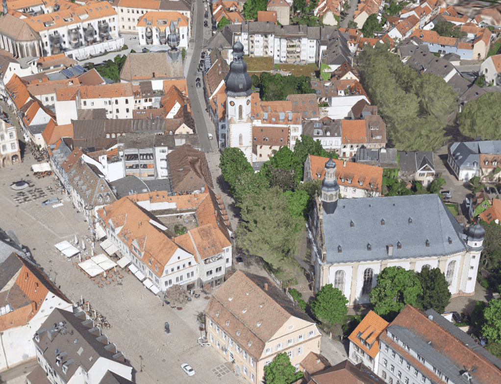
View of Speyer's historic city centre in the Digital Twin Speyer. The project is being jointly advanced by the City of Speyer and Stadtwerke Speyer.
Data is transformed into a comprehensive spatial picture
Data provides important insights into conditions and trends. Its spatial representation also shows where various factors intersect and how they interact with one another. This is exactly where the VC Map comes in. Virtual City Systems, together with its project partners, is responsible for the high-resolution digital map of Speyer. It is based on current aerial photographs and includes buildings, streets, and terrain. The web-based VC Map is directly connected to the urban data platform.
Specialist users can analyze different data layers together. This allows them to examine, for example, temperature trends, shading patterns, or the effects of greening and soil-unsealing measures. Underground infrastructure, such as electricity, water, and other utility networks, is also included in the analysis.
The open and modular VC Map supports various 2D and 3D geodata, specialized information, and sensor data. Thanks to documented interfaces and established standards, it can be integrated into existing system landscapes and flexibly expanded. Access is browser-based.

“An urban digital twin creates a shared view of the city. Information becomes understandable within its spatial context, impacts become traceable, and different perspectives are brought together. This helps municipalities make well-informed decisions and engage citizens. Speyer demonstrates just how much potential this approach holds.”
Measures can be evaluated in advance
Aerial photographs, data from a site survey, and hyperspectral measurements, among other sources, were used to create the digital twin. These not only provide high-resolution and visually appealing images but also detailed information about objects and surfaces, helping to identify areas of the city subject to thermal stress.
At the same time, the EDiT-Cities research project, in collaboration with the German Weather Service, is investigating scenarios related to heat stress and air quality. The Digital Twin visualizes the results of the climate simulations, making them accessible to decision-makers and citizens alike. In the future, an extension will also enable the provision of models for climate simulations via the digital twin. This will allow climate adaptation measures to be examined interactively and significantly accelerated.
Specifically, the digital twin is initially intended to support the redesign of Speyer’s city center. Various greening and soil-unsealing measures can be examined here in terms of their effects on the microclimate.
Virtual scenarios bring the effects to life
To complement the VC Map, RIWA is developing a virtual reality application based on the Unreal Engine. To do this, the digital city model is transferred into a virtual environment and linked to data from the digital twin and the urban data platform.
This makes it possible to experience simulations of heat stress, flooding, or traffic flows in a spatial context. Multiple people can explore the virtual city simultaneously, view scenarios, and discuss planning options together.
The application complements the technical work in the digital twin by providing a particularly vivid way to engage with the data and supports collaboration between planning, administration, and policymakers.
Understanding the City as an Interconnected System
The Speyer Digital Twin integrates three technological levels: the urban data platform, the VC Map as the spatial foundation, and the virtual reality application for selected scenarios.
For VCS, the key value lies in the integration of data and space. The VC Map creates a shared view of the city. Planning alternatives become comparable, potential impacts are easier to track, and complex issues become more understandable. The result is a modular system-of-systems—a prime example of a modern urban digital twin.
In this way, the digital representation of Speyer becomes a tool for climate-resilient urban development. Linked information fosters a better understanding of the city as a whole and supports informed decisions about its future.
Once it is made publicly available, the Speyer Digital Twin will be accessible directly from this page.