Bremen: A Digital Twin for compelling Urban Planning in 3D
How Bremen uses its 3D city model to make complex planning processes understandable for all stakeholders
A Pioneer of the Urban Digital Twin
Bremen is among the frontrunners of digital urban planning in Germany
With courage, expertise, and foresight, the team from land surveying, urban development, and IT transformed a hosted solution into an in-house 3D infrastructure – today a model for integrated urban development.
With the VC Suite, an interactive city model was created that makes complex projects visible and understandable – for technical experts, public administration, and citizens alike. Bremen demonstrates impressively how Digital Twins can transform the way we think about urban planning.
“With the VC Planner, we were able for the first time to convincingly showcase in 3D how a development project looks from different perspectives – for administration, policymakers, competition juries, and residents alike.”
Challenge: A 3D Tool that Reaches All Audiences
As the State Survey Office, our task was to provide a 3D building model in LOD1 and LOD2 standards. The solution
had to be technically robust yet accessible – usable by everyone from interns to the Chief Planning Officer. Initial research in neighboring states showed that existing solutions there did not meet our requirements.
The decisive impulse came from the Central Office for Building Coordinates, Building Footprints, 3D Building Models, and Cadastral Information (ZSHH), to which we deliver our geodata. They were already working with VCS products. This made it clear: a VCS solution would ensure both technical compatibility and organizational acceptance.
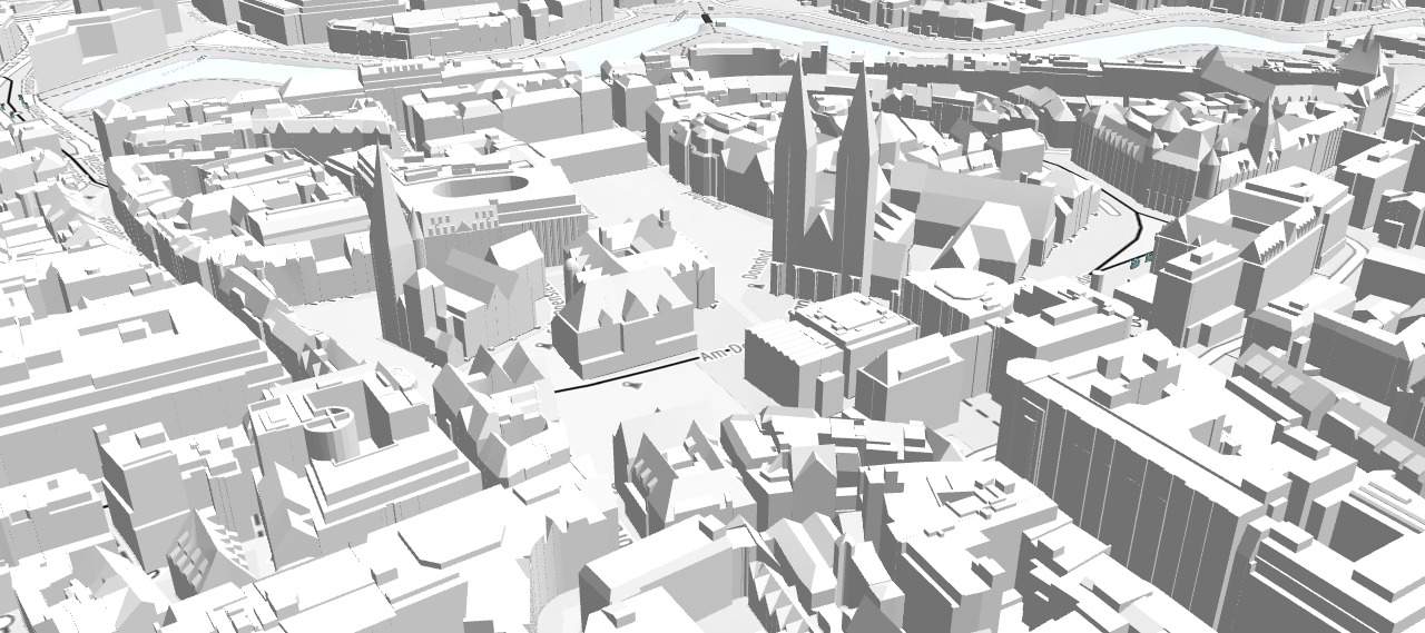
Fiure: Visualization of Bremen’s city center with St. Peter’s Cathedral, shown in a 3D city model at Level of Detail 2 (LoD2) based on CityGML.

“With the VC Suite, we created an interactive city model that makes complex projects visible and understandable – for professional planners, public administration, and citizens alike. Bremen demonstrates impressively how Digital Twins are reshaping urban planning.”
Objective: Making Complex Projects Comprehensible and Tangible
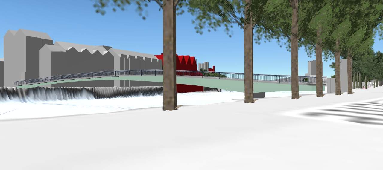
Figure: Pedestrian mode, with a view of listed buildings highlighted in red.
Our ambition went beyond providing raw data. We wanted a tool that would make urban development projects visible, verifiable, and communicable – an integrated part of everyday planning.
With the VC Planner, it became possible to:
- Present current planning stages in context
- Assess sightlines and building heights
- Integrate heritage conservation requirements
- Anchor discussions on a clear, visual foundation
Implementation: From Pilot Project to Established Planning Standard
In 2019, we began preparing our 3D building models with Building Reconstruction (BRec), soon followed by VC Map – hosted and easily accessible. We first encountered the VC Planner at the 3D Forum in Lindau and immediately recognized its transformative potential for our workflows.
We started with training sessions for individual urban planners. Through motivated staff, the user base grew steadily. Within just a few months, the Planner had become established and evolved into the tool of choice for design competitions, Projects under Section 34 of the Federal Building Code (BauGB), and political discussions.
“It immediately becomes clear how a project appears from street level or how shadows fall – this provides an objective foundation for discussions.”
Impact: Planning in New Dimensions
Today, the VC Planner is fully integrated into Bremen’s urban planning practice. The Digital Twin has been expanded with numerous modules: heritage conservation, wind and climate simulations, sightlines, textures – all integrated and tailored to diverse target groups.
A milestone project was the digital design competition for the Weser Bridge in 2022. Conducted entirely digitally during the later stages of the COVID-19 pandemic – anonymous, secure, and interactive – it won over even the most critical planners.
Other projects, such as flood protection, have also been realistically and transparently visualized with the VC Planner.
The new VC Story module further supports structured communication – for example, by engaging policymakers, citizens, and expert departments in complex projects such as City center development.
VC Planner in Practice
- Competitions: compare design models in the urban context
- Heritage Conservation: evaluate sightlines and height development
- Building Applications: project validation under §34 BauGB
- Politics and Administration: decision-making with spatial context
- Education: webinars, student projects, and outreach programs
Benefits of in-house hosting
- Faster data updates
- Independence in implementing extensions
- Security through our own infrastructure
Looking ahead, we are focusing on practical innovation:
in a new project, local weather data is integrated live into the 3D model. The aim is to generate precise forecasts based on sensor data – with real added value in everyday life, for restaurants, residents, and the urban climate.
Technology & Outlook: In-House Operation and New Use Cases with Weather Data
Since 2023, we have been running all VCS products in-house. The migration took place step by step, supported by on-site training from VCS.
Figure: Winning design of the urban development competition “Umgedrehte Kommode” with analysis of shadow patterns.
“Success lies in the ability to make planning comprehensible, verifiable, and tangible.”
Conclusion: From Digital Tool to Integrated Planning Strategy
The VC Planner in Bremen has evolved from a digital tool into a strategic foundation of urban planning – driven by committed people, open interfaces, and the ambition to shape urban development inclusively.
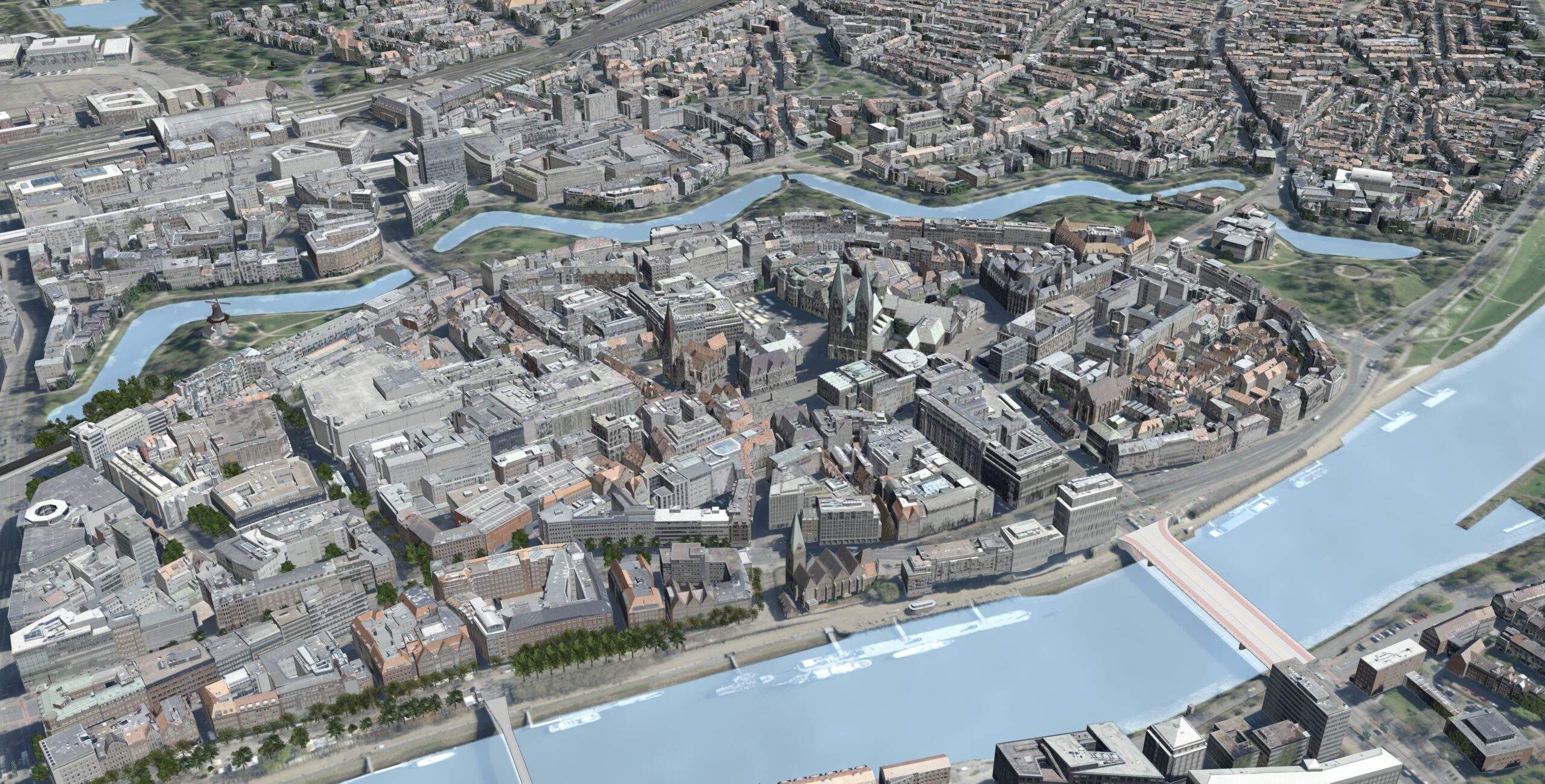
Figure: Photorealistic 3D visualization of Bremen’s historic city center based on a textured city model. The detailed representation with orthophoto textures supports urban planning, communication, and decision-making processes.
VC Planner as a strategic tool
Are you looking for your own 3D infrastructure for digital urban development?
We would be happy to show you how to make your plans comprehensible, transparent, and easy to understand — for city administrations, politicians, and residents.

“With the VC Suite, we created an interactive city model that makes complex projects visible and understandable – for professional planners, public administration, and citizens alike. Bremen demonstrates impressively how Digital Twins are reshaping urban planning.”