New ReleaseVC Suite
VC Suite Release 2026 is available now. Discover the new features for Urban Digital Twins.
With the new release of the VC Suite, Virtual City Systems is setting the technological course for the coming years. The release includes VC Publisher 6.0, VC Map 6.3, VC Database 5, and VC Warehouse 6.0.
An overview of the highlights of the new release:
- VC Publisher Version 6.0 features a modernized user interface, support for additional data sources, optimized workflows, and a significantly more powerful technical foundation. With this comprehensive redesign of the user interface, we are phasing out outdated frameworks and laying the groundwork for the future development of VC Publisher.
- At the same time, we are releasing VC Map 6.3 with new features for the Panorama Viewer, a new guided tour for a quick start, dynamic attribute data, and many other improvements.
- With the official release of VC Database 5, we now offer full support for the new database version in all our products, as well as support for CityGML 3.0. The new VC Warehouse 6.0 now also fully supports VC Database 5.
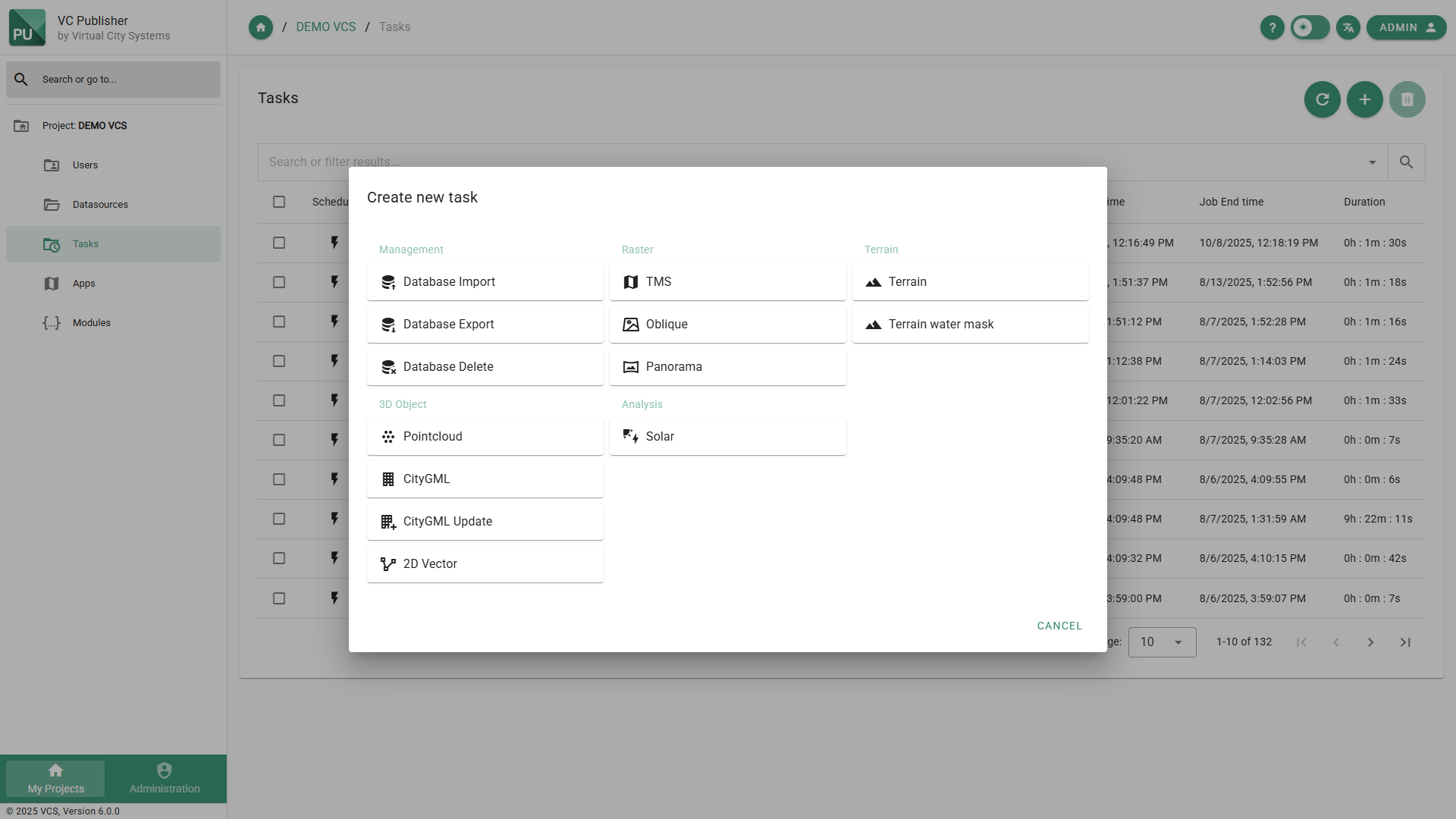
A modern publishing tool: VC Publisher 6.0
VC Publisher 6.0 has been completely redesigned. The new user interface features a modern and intuitive design. All functions and processes of the user interface now make use of the Publisher REST API. This not only makes daily work more organized, but also more consistent and efficient. By integrating the REST API into automated workflows and processes, the Publisher can also be controlled entirely without the user interface if necessary. You can find the updated online documentation on our VC Help page for VC Publisher.
The screen displays the new user interface, which focuses on tasks for converting geodata into high-performance formats for web visualization:
With version 6.0, we now support the processing of panoramic images from mobile mapping campaigns for display in our Panorama Viewer.
The new Panorama Task requires equirectangular images and metadata regarding the capture locations (location, orientation, capture time) and uses these to generate panorama layers for integration into VC Map. If additional point clouds are available, they can be included in the processing to calculate a depth and intensity image for each panorama. This enables, among other things, precise 3D measurements directly within the panoramic image. You can find the input data specifications (PDF) here.
The processing supports survey data from various providers and camera systems and has been successfully tested with data from Trimble MX60, IGI StreetMapper, eagle eye technologies, and Cyclomedia.
The VC Panorama Converter is a paid add-on for VC Publisher. The viewer component, on the other hand, is integrated into VC Map and is therefore freely available.
With this release, VC Database 5 exits beta status and is now fully supported in VC Publisher 6.0. Compared to the previous version, 3D city models can now be managed in accordance with the current CityGML 3.0 standard. New tasks are available in Publisher for working with the VC Database:
- Import, Export, and Delete tasks, which allow CityGML/CityJSON data to be imported, exported, deleted, and updated in a VC Database via the new Publisher interface.
- A new CityGML task for preparing data from the VC Database for visualization in VC Map.
All tasks continue to support VC Database 4 as well. An immediate upgrade of existing database instances to version 5 is therefore not required.
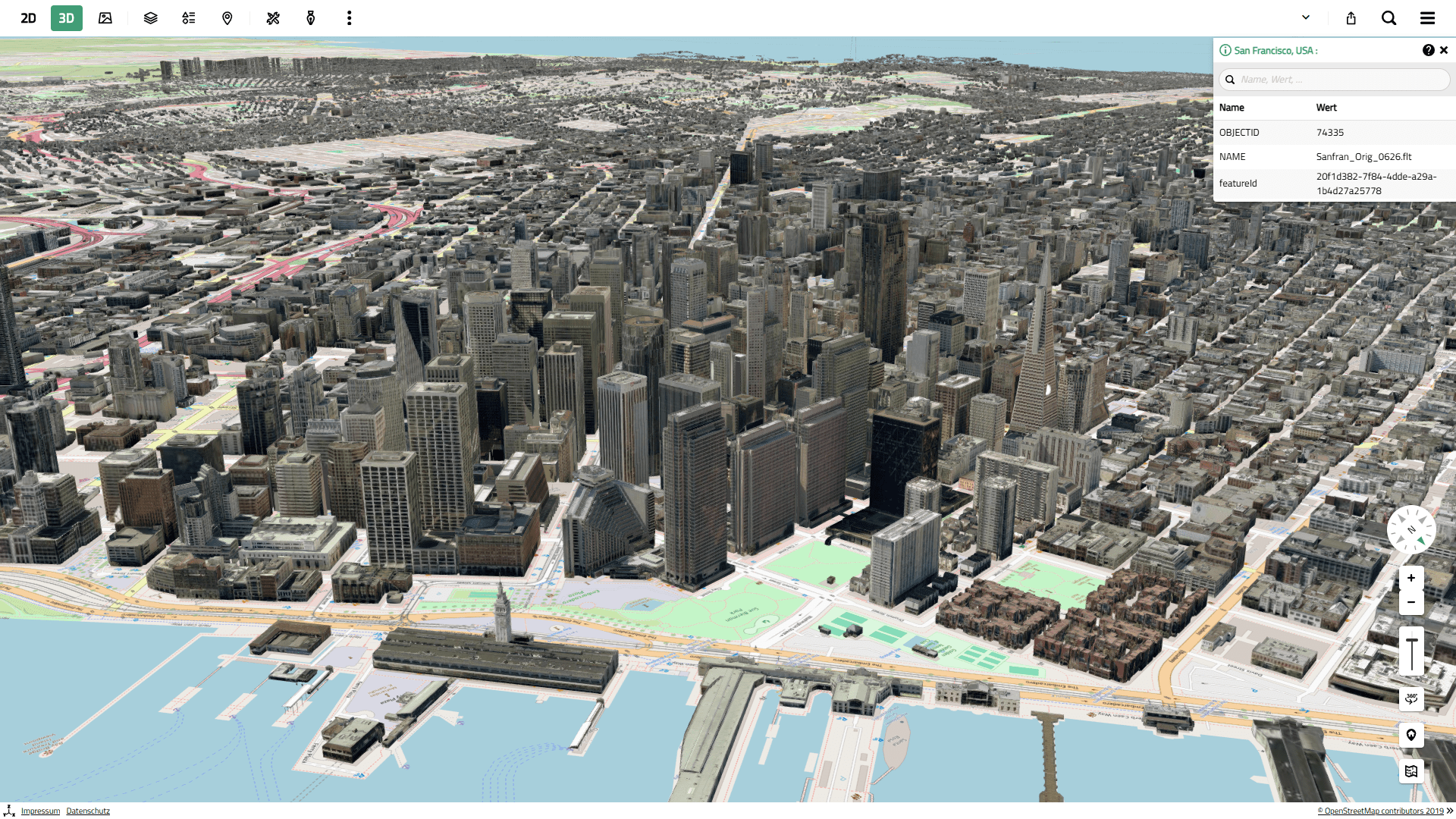
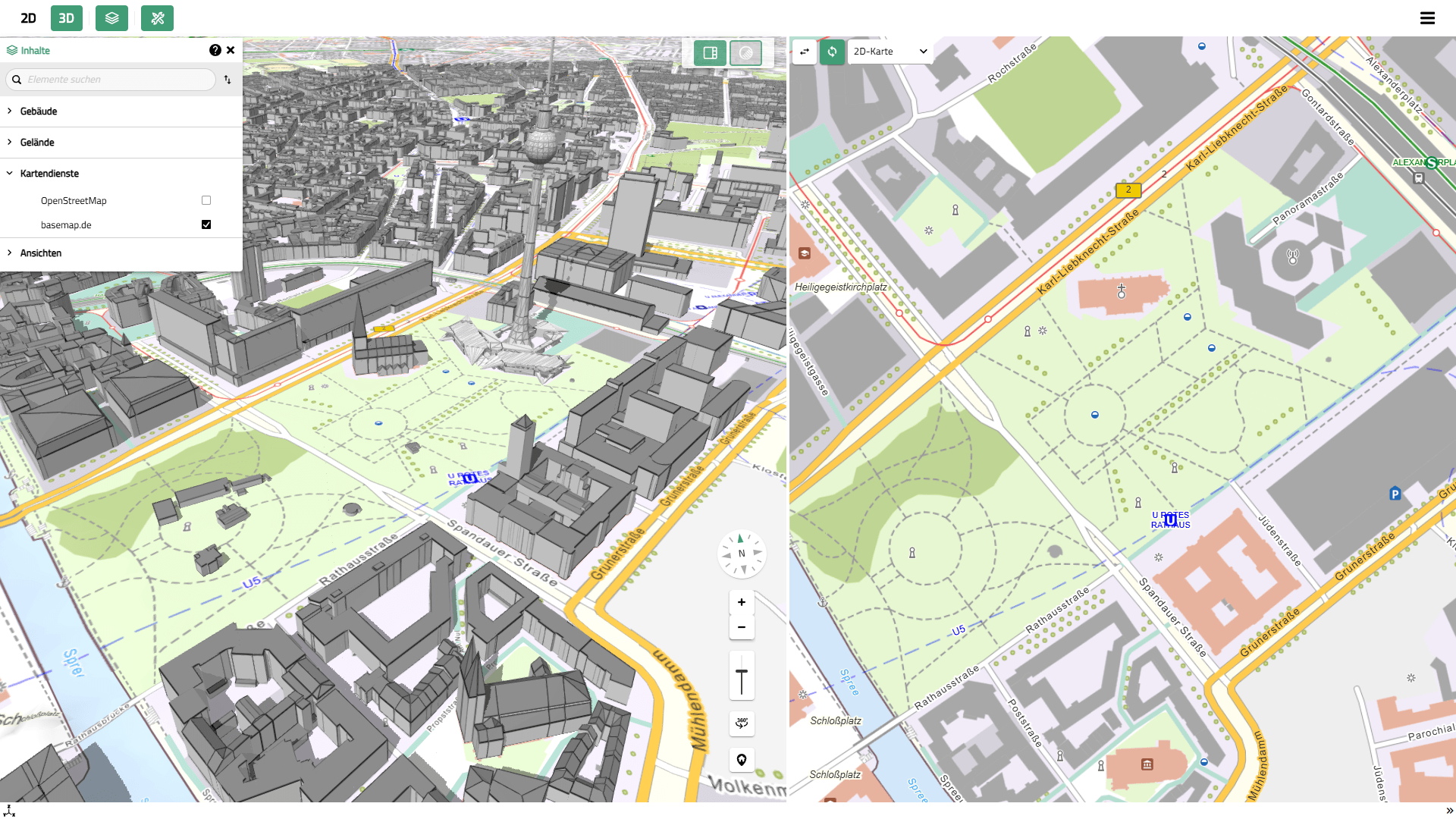
With VC Publisher 6.0, we support numerous new data formats and standards that can be registered directly as data sources and visualized in VC Map without additional conversion. These include, among others:
- Indexed 3D Scene (I3S) – The 3D web streaming format from ESRI and an OGC Community Standard. To be used in VC Map, the data must be in a global coordinate system (screen 1).
- Mapbox Vector Tiles (MVT) – A tiled format for the high-performance display of 2D vector data with high rendering quality. With VC Map, MVT datasets, including styling information, can be displayed not only in 2D but also in 3D (screen 2).
- FlatGeobuf (FGB) – A modern, binary geodata format for 2D vector data, specifically developed for high performance, streaming, and cloud usage.
- Cloud Optimized GeoTIFF (COG) – A tiled raster format with resolution pyramids for the efficient loading and display of large raster data via the web and from cloud storage.
- Panorama – A new data source for panoramic images. Datasets can be created using our new Panorama Task or integrated from external processes, provided they comply with the open data specification.
VC Publisher 6.0 offers new and revised tasks for converting geodata into high-performance web visualization formats:
- The CityGML task replaces the previous 3D Object task and has been extensively revised. In addition to support for VC Database 5, it now also supports the latest version 1.1 of OGC 3D Tiles. With many new options, such as for generalizing and compressing geometries and textures (e.g., Draco, KTX2), even more efficient and high-performance visualization data is generated from CityGML/CityJSON.
- The 2D Vector Task enables the import of even large GeoJSON datasets, their extrusion, and output as 3D Tiles 1.1, thereby supporting end-to-end 2D/3D workflows.
In addition to the highlights mentioned above, VC Publisher 6.0 includes numerous other improvements, including:
- Improved management and editing of apps and modules. Modules can now be easily duplicated, and recent changes can be undone step by step.
- An enhanced preview function for data sources, which now allows all data sources in the active project to be included.
- Easy duplication of data sources, cleanup of orphaned data sources, and deletion of obsolete tasks.
- New logging system for generating access, audit, and app logs.
- Operation behind reverse proxies (e.g., /publisher/) is possible.
- Enhanced security through additional security headers (including CSP) and improved SSL support.
- Simplified configuration via environment variables and .env files.
- Update to js 24 and Java 21.
VC Map: Highlights and New Features
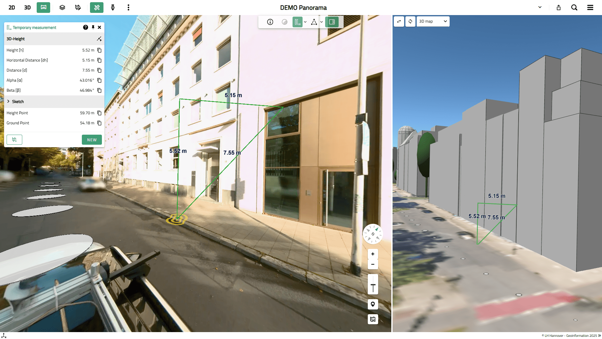
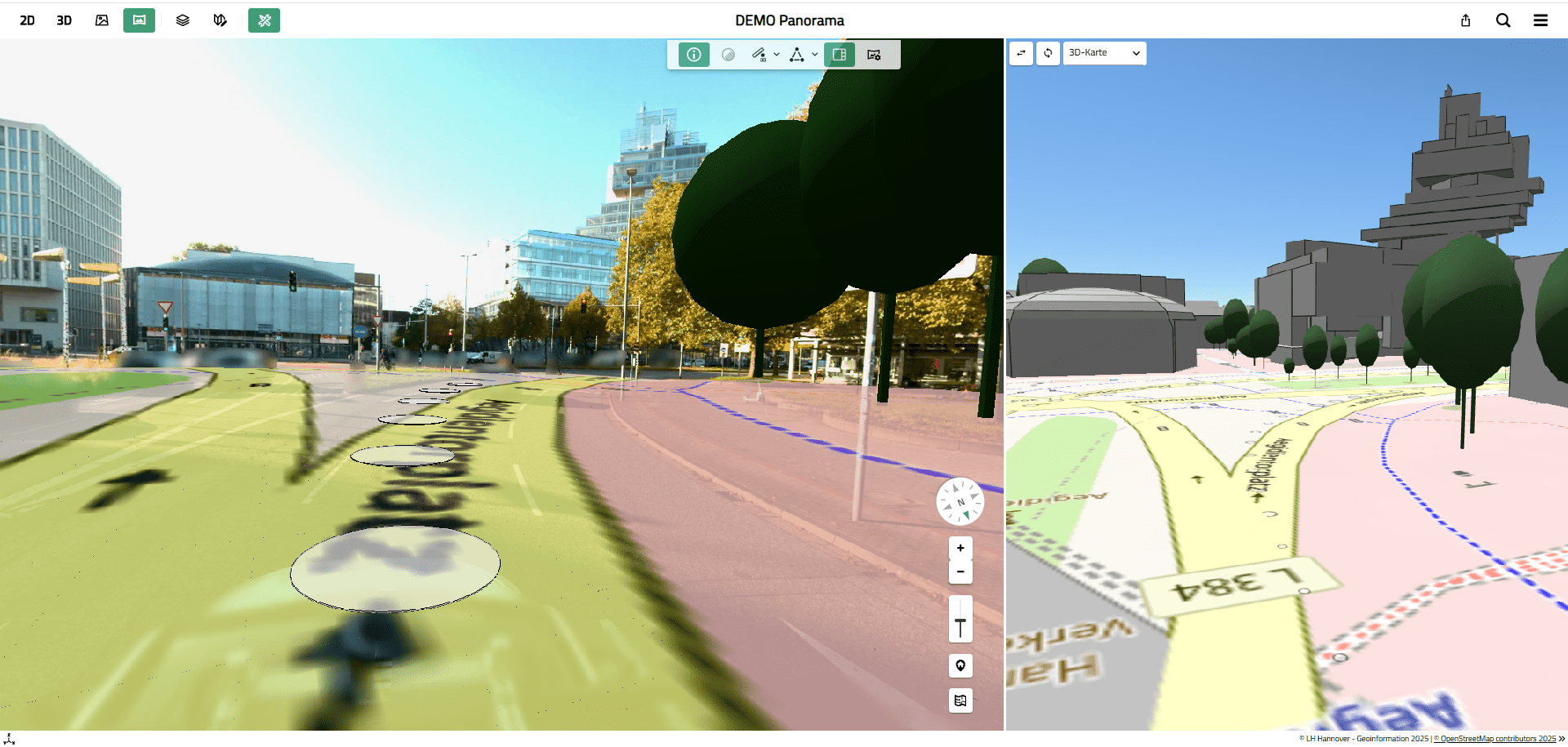
With VC Map 6.3, we are expanding the Panorama Viewer with new features and analysis tools, as well as the ability to overlay additional 2D and 3D data directly onto the street-level views.
- Precise measurement of distances, elevations, and objects directly within the panoramic image based on 3D coordinates (screen 1)
- Digitizing and capturing objects in the panoramic image and transferring them to other map views in VC Map (2D, 3D, oblique aerial images)
- Overlaying map services (e.g., WMS) and vector layers (e.g., WFS or GeoJSON)
- Overlaying 3D objects, point clouds, and 3D layers (e.g., CityGML, 3D meshes (screen 2)
Depth images are required for 3D measurements and digitization functions; these are automatically generated from the captured point clouds using the new Panorama Task in VC Publisher 6.0.
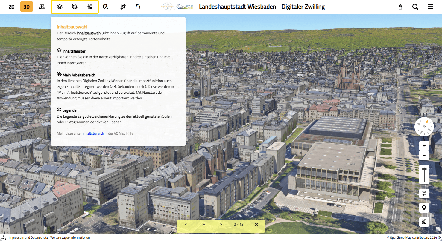
The new Guided Tour provides a context-sensitive introduction to a VC Map and launches automatically when the application is opened. It guides users step by step through key features and tools, explaining them with clear help texts.
This makes it particularly suitable for public geo-portals and users without WebGIS experience. The content dynamically adapts to the features currently available in the VC Map application. The Guided Tour can be activated and used for any VC Map.
The screen shows the guided tour of the Wiesbaden Digital Twin:
With VC Map 6.3, attribute information from external sources such as CSV and JSON files, as well as JSON-based services, can be dynamically linked to 2D and 3D objects in VC Map. The attribute data is retrieved at runtime as needed and displayed in the FeatureInfo window of the corresponding objects, or it can also be used for dynamic styling of all objects in a layer.
This means that attribute data no longer needs to be integrated into the visualization data in advance; instead, it is decoupled from it and only integrated at runtime (Linked Data approach).
VC Map 6.3 also includes additional improvements and optimizations:
- General stability and performance improvements
- New layer types (I3S Layer, Maxpbox Style Layer)
- Various bug fixes and UI improvements
An overview of all other new features and improvements can be found on our GitHub page for the VC Map Open Source Project.
VC Database 5.0 – The Backbone of Your Urban Digital Twin
With this release, VC Database 5.0 officially exits beta status and is now fully supported in all VC products.
The most significant new feature is the ability to manage and maintain 3D city model data in the latest versions of the OGC standards CityGML 3.0 and CityJSON 2.0. Earlier versions of both standards continue to be supported. The database schema of VC Database 5.0 has been completely restructured and greatly simplified to improve both data management and the integration of the VC Database with standard GIS tools, as well as its integration into automated processes.
With support for CityGML 3.0, the VC Database will continue to serve as a central core component for the implementation of Urban Digital Twins. It continues to be based on the open-source 3D City Database, which we actively help shape as core developers.
VC Database 4 will continue to be supported and maintained for an extended transition period, allowing migrations of existing database instances to be carefully planned and implemented in stages. We are happy to assist you with any questions regarding the migration.
VC Warehouse 6.0 – Data Hub for 3D City Model Data
With VC Warehouse, 3D city model data from the VC Database can be converted into various target formats and made available for different applications. By integrating with our VC Map, download portals for 3D city model data can be easily implemented.
New features in version 6.0 of VC Warehouse include:
- Full support for VC Database 5 and CityGML 3.0. VC Database 4 is also still supported.
- Support for FME Flow and FME Form versions 2025 and 2026.
- Switch to FME API v4 for secure communication between VC Map and FME Flow.
- Numerous improvements to the conversion processes for various output formats.
Do you have questions about the new release or its features? Please contact us. We look forward to hearing from you.

“This latest release of VC Suite once again includes improvements based directly on feedback from our customers. That is particularly important to us.”