Neues ReleaseVC SuiteWebinar
VC Suite Release 2026 at a glance: VC Publisher 6, Panorama Viewer and new data workflows
In the webinar held on May 12, 2026, Tim Wendt, Head of Customer Support at Virtual City Systems, gave a practical introduction to the new VC Suite Release 2026. He showed how data workflows and panorama analyses are evolving on the basis of the new technical foundation.
VC Suite Release 2026: Which components are included?
With the 2026 release, Virtual City Systems bundles several key product updates within the VC Suite for Urban Digital Twins:
- VC Publisher 6.0
- VC Map 6.3 (including Panorama Viewer 2.0 and Guided Tour)
- VC Database 5
- VC Warehouse 6.0
The webinar made one thing clear: the release is not only about adding new features.
The focus is on a clearer structure and improved performance. This forms the technical foundation for automation and further development.
VC Publisher 6.0: New workflows for geodata conversion and app management
VC Publisher has been completely overhauled with version 6.0. The new user interface is clearer, more modern, and consistently aligned with recurring day‑to‑day workflows.
Key improvements include:
- clear separation of projects, apps, modules, data sources, and tasks
- a modern light and dark theme
- improved administration with transparent user activity tracking
- versioning and history for modules to support secure editing
One important technical step: all user interface functions are now based on the Publisher REST API. This means that conversions, data imports, and app management can be controlled not only manually, but also through automated workflows.
Panorama workflows in VC Publisher 6: analyzing street‑level data instead of just viewing it
One of the central highlights of the release is the support for panoramic images from mobile mapping surveys. With the new Panorama Task in VC Publisher 6.0, panoramic images can be prepared in a targeted way for use in VC Map. Metadata on location, orientation, and capture time is taken into account directly.
The workflow includes:
- registration of equirectangular panoramic images
- integration of metadata on location, orientation, and capture time
- optional inclusion of point clouds for calculating depth and intensity images
The processed datasets are then available as a dedicated data source in VC Map.

“VC Publisher 6 is not just visually new. We have fundamentally reworked it from a technical perspective to make it more consistent, more secure, and more suitable for automation – and therefore future ready.”
VC Map 6.3: Panorama Viewer 2.0, synchronization, and analysis
In VC Map 6.3, the new panorama datasets unfold their full potential. Panorama Viewer 2.0 goes far beyond simply viewing images and enables real analytical work:
- precise measurement of distances, heights, and objects directly in the panoramic image
- digitizing objects in the street environment
- parallel views of the panoramic image, 2D map, and 3D scene
- overlaying additional data such as point clouds, CityGML models, or planning data
Synchronizing these views allows data to be compared in its spatial context. This represents an important step toward integrated street‑level analysis.
In addition, the Guided Tour provides a context‑sensitive introduction that is particularly helpful for new users and public audiences.
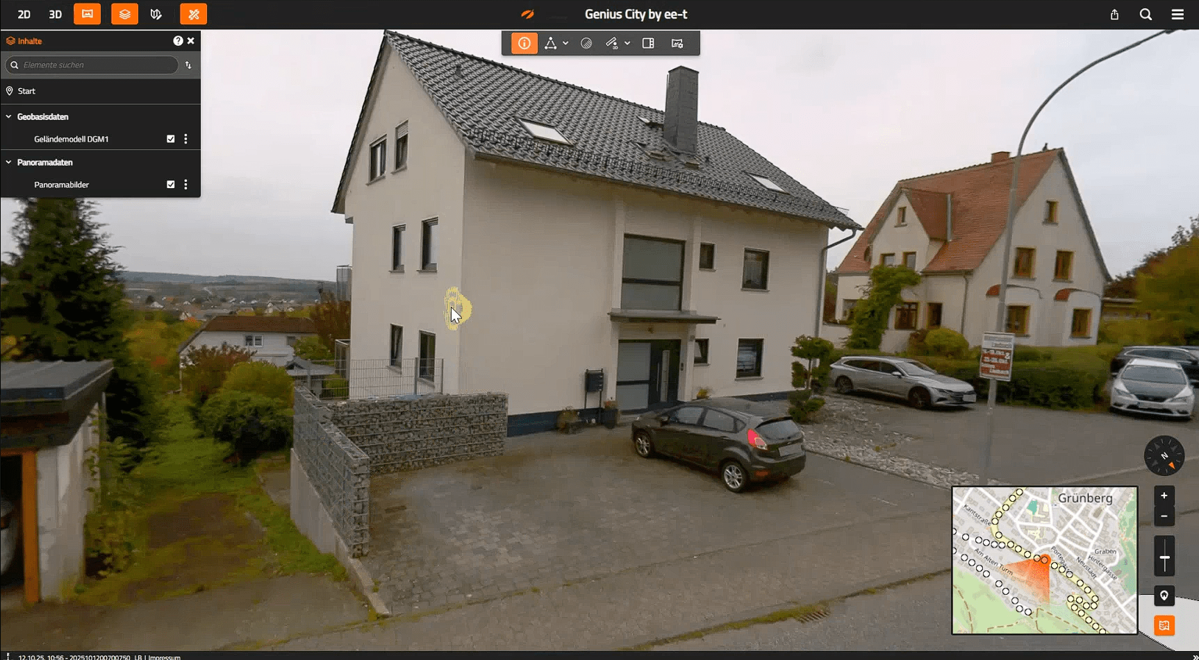
The cursor follows the building structure precisely. Depth information is derived from the underlying point clouds. © eagle eye technologies
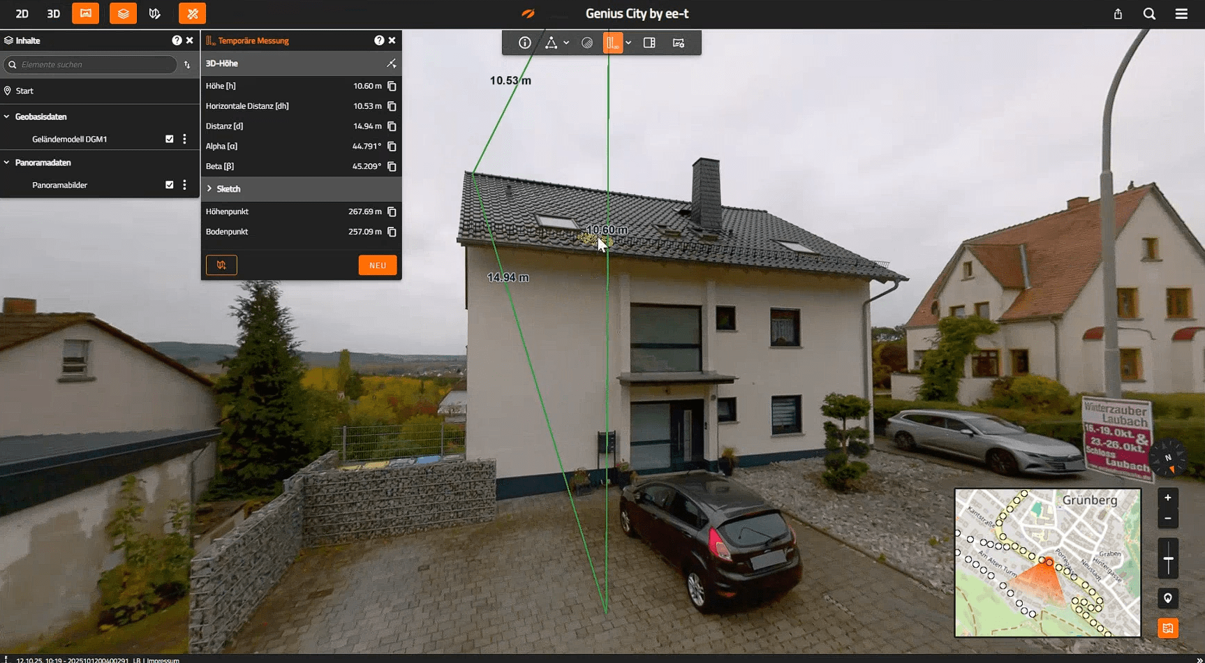
Height measurement from ground to roof directly within the panoramic image. © eagle eye technologies
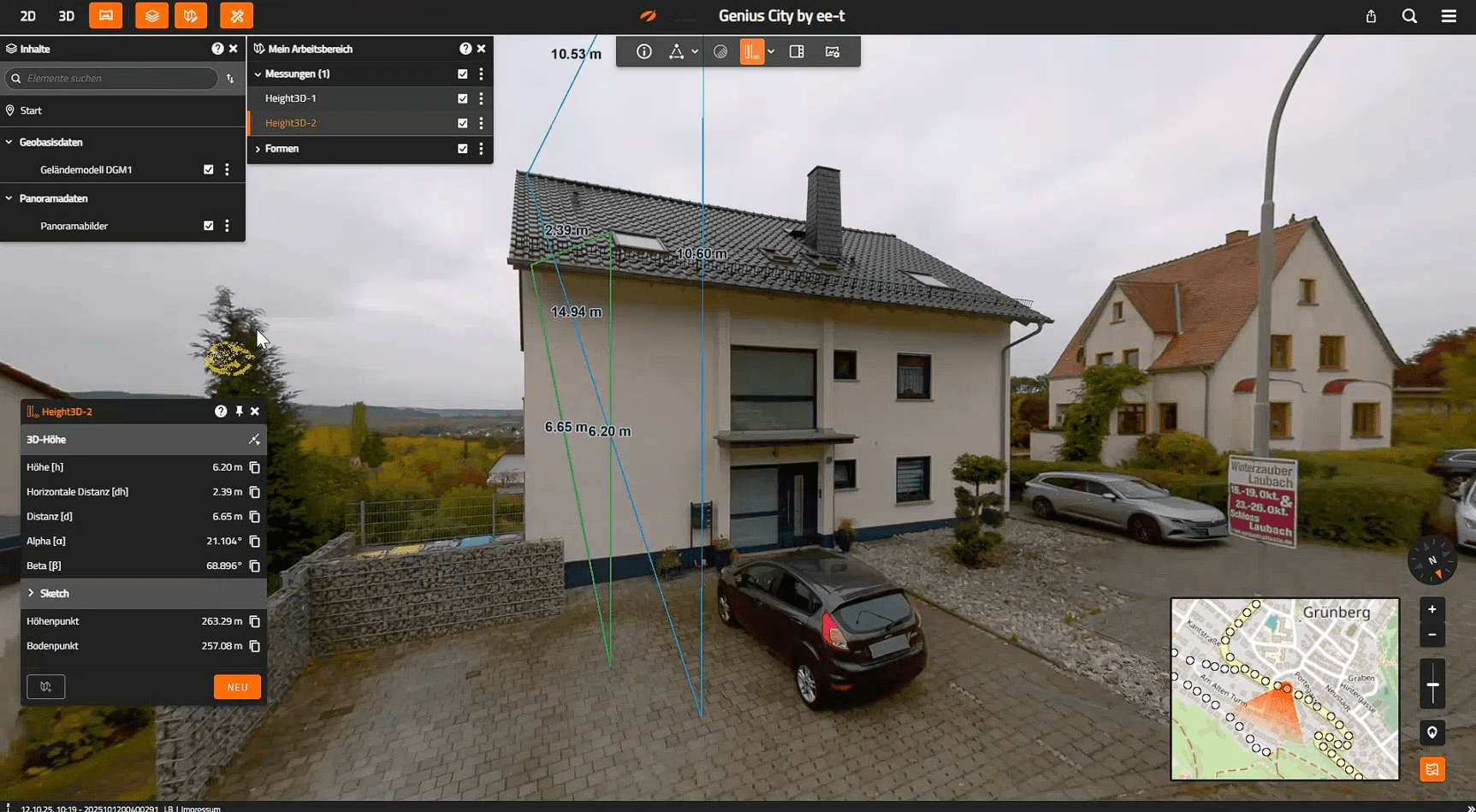
Direct comparison of total height and building wall height in the Panorama Viewer. © eagle eye technologies
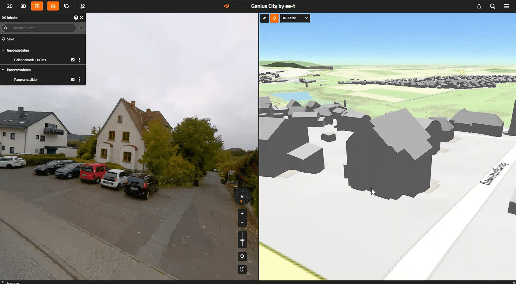
Side-by-side view of Street View and the 3D city model. © eagle eye technologies
New tasks and data formats: CityGML, 2D vectors, and database management
Alongside the Panorama Task, additional conversion and management functions have been introduced or revised:
- The CityGML Task replaces the former 3D Object Task and supports OGC 3D Tiles 1.1 as well as integration with VC Database 5 (including CityGML 3.0).
- The 2D Vector Task enables high‑performance processing of large 2D vector datasets (e.g., GeoJSON) for end‑to‑end 2D/3D workflows.
- New Database Management Tasks (Import, Export, Delete) replace the former importer/exporter interface of VC Database.
All core tasks continue to support VC Database 4, allowing migrations to be planned and carried out step by step.
Technical foundation: security, maintainability, scalability
Numerous technical improvements have been implemented behind the scenes, including:
- operation of VC Publisher behind reverse proxies
- simplified configuration via environment variables
- extended logging for audit and access purposes
- updates to Node.js 24 and Java 21 to address security vulnerabilities
In parallel, the documentation has been restructured and is now centrally available at help.vc.systems.
Q&A: Questions from the webinar
No. Integration is planned for a future Publisher version.
Yes. Brightness and contrast can be adjusted directly using sliders in the panorama tools.
Yes. In addition to on‑premises installations, cloud setups are also possible.
Yes. Panorama data processing can also be provided as a service if required.
Conclusion: VC Suite 2026 as a foundation for powerful Digital Twins
The webinar on the VC Suite Release 2026 clearly showed that this is far more than a conventional update. With VC Publisher 6.0, VC Map 6.3, VC Database 5, and VC Warehouse 6.0, Virtual City Systems provides a structured and high‑performance foundation for Urban Digital Twins. It spans the entire workflow, from data preparation to analysis within VC Map.