3D City ModelUrban SimulationWater
3D simulations for modern flood risk management
Floods have been with us since time immemorial. However, the straightening of rivers, the steady advance of soil sealing and the increase in extreme weather events, combined with dense settlement, mean that flood events are becoming increasingly extreme. The potential danger for our entire infrastructure, for our environment and not least for us humans has increased considerably as a result.
Content
<em>Digital modeling of flood events</em>
In order to better prevent these hazards in the future, holistic flood risk management across river basins is needed. Numerous guidelines, ordinances and strategies for flood protection already exist. However, the topic of flooding has long since ceased to be the exclusive preserve of experts and has become a matter of public concern as citizens become increasingly worried. The pressure to act on flood protection is growing. Affected and interested citizens want to be educated on the subject of flooding and understand the risks. This requires tools that make this possible – the digital twin.
In what way can a digital twin contribute to flood risk management and who benefits from it?
To provide a better understanding of flooding and flood risk management specifically in urban areas, Virtual City Systems developed a novel methodology of detailed flood risk analysis together with the Dutch company Nelen & Schuurmans. For the first time, hydrodynamic-numerical (HN) simulations are combined with detailed, semantic 3D city models.
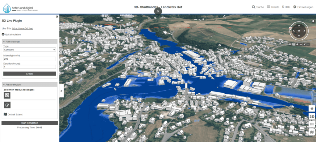
On the basis of our VC Map, a web-based city model platform that the end user can access directly via a browser, processes of flood events are mapped in 3D.
All available and processed data for flood risk management are combined in the VC Map and made available for the definition of flood scenarios. For example, temporarily erected barriers made of sandbags or sheet piles can be modeled as measures of operational flood protection in the Digital Twin and taken into account in the simulation. The most important basis for this is the digital terrain model, such as that collected and provided by the Federal Agency for Cartography and Geodesy.
In order to simulate floods in high quality, the dataset is processed in such a way that obstacles, such as the footprint of buildings, bridges and culverts, but also the riverbed itself are included in the terrain model.
Other important data sets include land use and soil type. This information is used in combination with data from roads and buildings to derive infiltration rates and friction rates.
<em>Historical or predicted runs of the flood model</em>
To simulate floods, the previously mentioned datasets are uploaded to the 3Di platform. This simulation platform calculates how the water flows and solves the full Saint-Venant equations with conservation of mass using subgrid, quadtree and cloud technology. Precipitation input here can be via areal rain or local rain. Users can also integrate precipitation forecasts from the German Weather Service (DWD) ICON D2 weather model to illustrate the impact of upcoming weather events. Simulation of historical events is also possible using RADOLAN’s radar-observed precipitation data, which further supports the validation of the model.
Most importantly, heavy rainfall scenarios can be studied, such as may have occurred in the region, but not in every location. If these results are published in the easily accessible and self-explanatory web map application, this will enable emergency services and those responsible on the ground to prepare for possible scenarios and to react more quickly, clearly and in a more targeted manner in the event of an emergency.
It also provides a basis for examining exactly which measures or design decisions in public spaces will help mitigate the impact of flooding in the future.
<em>Advantages of Visualization in the Digital Twin</em>
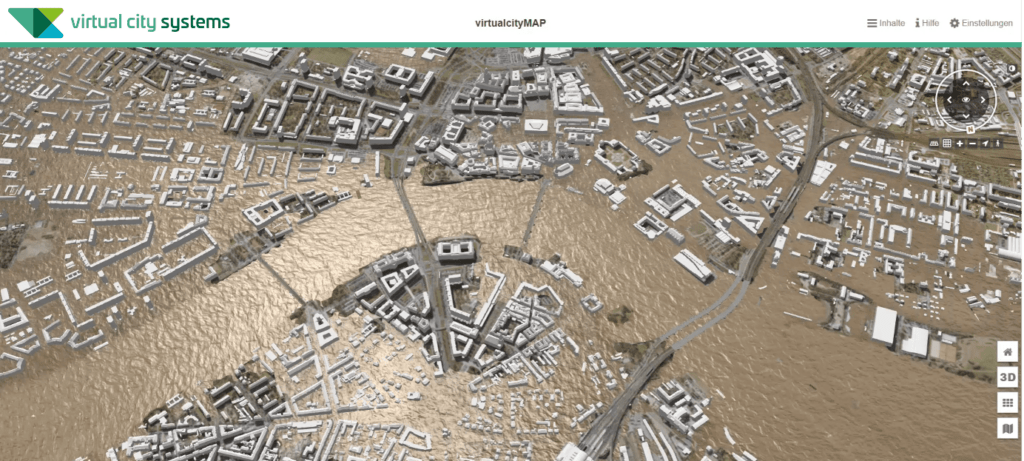
The simulation results for selected city areas can be visualized photorealistically as water levels with waves and reflections in the context of the 3D environment after they have been imported into the Digital Twin. In addition, the calculated water levels and flow velocities can be evaluated for all buildings and locations. Animated film sequences or virtual sightseeing flights are also possible in order to convey the flow and the dangers it poses even better.
The 3D visualization in the digital twin of simulation results, such as water levels, flow velocities, water depths and specific discharges, has many advantages. On the one hand, flood hazards can be communicated to affected and interested citizens in a clear and understandable way, thus increasing risk awareness. On the other hand, the digital twin and the visualization of flood scenarios create a better basis for informing decision-makers.
Beyond the pure visualization, it is also possible to determine concrete flood damage. The damage forecasts for a flood scenario can be created for individual buildings or even for an entire city district. For this purpose, the damage is calculated as a function of the building footprint as well as the local water depth. Detailed attribution of buildings, e.g. by specifying the number of people and the type of building use, will also make it easier to plan and estimate evacuation measures for specific flood scenarios in the future.
Coupling Digital Twins with hydro-numerical simulations contributes to the advancement of modern flood risk management. This includes risk minimization for our entire infrastructure, for our environment and for us humans. With a realistic and purposeful 3D visualization of the central simulation results in the Digital Twin, flood protection can now be communicated to the public in an understandable way.
Want to learn more about flood simulations?
<em>Request more information</em>
Do you already know our media partner <em>Urban Digital</em>?
You can find more information and technical articles on the topics of Digital Twins and simulation on the Urban Digital website!


