Automatically Detecting Solar Systems: A GeoAI Analysis with VC Map
How can the expansion of solar energy in cities become visible when no complete public datasets exist?
This question motivated Hanna Kretz, a working student at Virtual City Systems (VCS) and a master’s student at the University of Potsdam, in her interdisciplinary project. She developed a GeoAI‑assisted workflow to identify installed solar systems in urban aerial imagery. While each step of the workflow was manually executed and evaluated, the recognition itself was automated by the AI model. The results provide valuable impetus for data-driven energy planning and might in future support municipal offices in assessing solar expansion.
Update from November 12, 2025: Hanna Kretz wins 2nd place with her project work at the GeoIN MINT Award
We are very happy and proud of Hanna and her outstanding achievement. This year’s GeoIN MINT Award had two winners in total, with first place going to a comprehensive school. The award ceremony took place on Tuesday, November 11, 2025, as part of the 13th German GeoForum in Berlin. Hanna submitted a three-minute video presenting her project for the award.
Background: Why Do Cities Need Better Solar Data?
In German cities, no public, complete datasets of installed solar systems (with precise location data) currently exist — a clear gap for digital urban planning. While VC Solar, one of VCS’s software components, computes solar potential on rooftops and open spaces, this project focuses on a complementary approach: identifying already installed solar installations via AI‑assisted image analysis.
Objective: Solar System Detection as a Data Basis for Urban Planning
The project’s goal was to develop a workflow to identify installed solar systems in urban areas using orthophotos. Since comprehensive public datasets of installed solar systems do not exist in Germany, municipalities lack a robust foundation for analyses and planning. This workflow aims to help fill that gap and could in future serve as a data layer in VC Map.
The workflow was tested with the 2023 orthophoto of Berlin. The goal: identify solar systems across the entire city and evaluate the accuracy of detection.
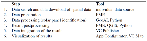
Figure 1: Developed workflow and tools used during the project for solar system detection with GeoAI.
Method: How GeoAI Was Applied for Detection
For detection, the open‑source platform GeoAI was employed — a powerful Python framework combining artificial intelligence and geospatial data analysis. As a starting point, a pretrained Mask R‑CNN model was used, but it produced too many false positives and false negatives. Therefore, additional training runs were performed using manually labeled training data.
After comparing several model variants, the one showing no signs of overfitting was selected. This model was then applied for the city‑wide analysis in Berlin.
Results: Accuracy, Limitations, and Potentials
The core data analysis using GeoAI took approximately ten days. The results then underwent post-processing and examination. The biggest challenge was the lack of reliable reference data to precisely quantify detection accuracy.
Nonetheless, all indications point to an average detection accuracy of around 70 %. GeoAI showed weaknesses especially in distinguishing skylights, shadowed roof areas, or glass canopies. To improve detection performance in future applications, additional data sources such as hyperspectral imaging could be incorporated.
Despite the limited accuracy, the results suggest that a time‑series analysis with bias correction might still yield valuable insights — for instance, about the growth of solar installations in specific neighborhoods or entire cities over time.
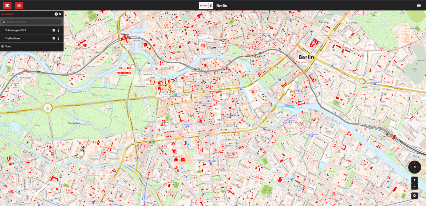
Figure 2: The results of the solar systems identified in Berlin for the year 2023, integrated into VC Map.
Layer: OpenStreetMap & vector layer with red polygons representing each detected solar system.
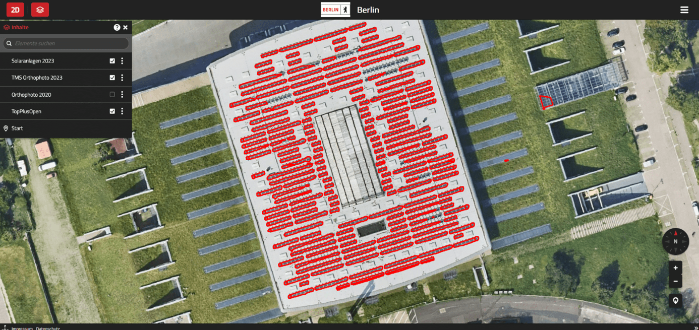
Figure 3: Example of a gym in Berlin with solar systems. Most, but not all, solar elements are detected.
Layer: Orthophoto & vector layer with red polygons representing each detected solar system.
Application Value for Cities and Planning Authorities
For municipal environmental departments, Smart City units, and planning authorities, the developed approach offers substantial potential. With further model refinement, it could provide a new data foundation for evaluating and planning renewable energy in urban environments.
Rather than relying on costly field surveys or incomplete registry data, the actual level of solar installation could be derived directly from up‑to‑date aerial imagery. This enables data-driven decisions in promoting, densifying, or monitoring municipal energy policies.
Conclusion: Research Impulse for Practice
Through her project, Hanna Kretz has charted an exciting application area for GeoAI and demonstrated how university research can result in practice-relevant solutions for the digital city. The findings offer important impulses on how existing VCS products such as VC Solar and VC Map might be augmented by AI-driven data detection — a further step toward smarter, more sustainable cities.