VC Panorama
Software for 360° panoramic images
What is VC Panorama?
VC Panorama is an extension module from Virtual City Systems for integrating, displaying, and analyzing 360° street-level views in VC Map.
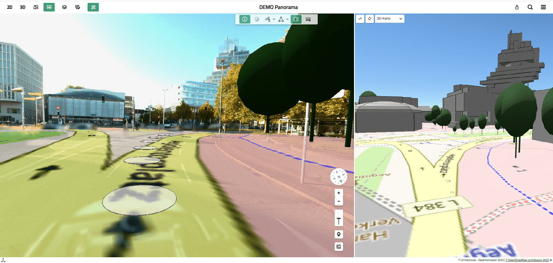
The extension module supplements the 2D, 3D, and oblique aerial map types in VC Map with a panorama viewer that provides realistic insights into street environments and enables technical analyses directly within the image.
VC Panorama consists of two components:
- a component for visualizing panoramic images in VC Map—for example, from street-level surveys,
- the VC Panorama Converter in VC Publisher—for processing and integrating the panoramic data into VC Map.
Thanks to the seamless integration of the panoramic data into VC Map, all geodata can be used in a unified viewer—regardless of the survey service provider. A separate viewer for panoramic images is not necessary.
VC Panorama is designed for municipalities, planning offices, and infrastructure operators that document, analyze, or evaluate street spaces—and can also be used for individually captured panoramas or other georeferenced 360° images.

“Our goals were clear: move away from isolated solutions and toward a shared database. With VC Panorama, we integrate image-based reality directly into the geoportal—measurable, analyzable, and accessible to everyone. This makes coordination faster, decisions more reliable, and our work more efficient overall.”

Scope of services offered by VC Panorama
VC Panorama enhances VC Map with an integrated 360° view and enables technical analysis of panoramic images within the context of the digital 3D city model or other geodata. VC Panorama is suitable for integrating panoramic images from mobile mapping drives as well as panoramas captured from stationary positions.
The scope of services includes:
- Display and navigation of 360° panoramic images along defined driving routes or at specific locations
- Geolocation of capture locations in 2D and 3D views
- Support for driving data from various providers and camera systems, provided they meet the defined data requirements
- Synchronized display of panoramic images with 2D, 3D, or oblique aerial imagery
- Integration of any number of survey campaigns or individual panoramas
- Ability to overlay vector data (e.g., WFS or GeoJSON) and 3D objects onto the panoramic image
- Drawing and measurement functions based on georeferenced 3D coordinates, provided that additional depth information from point clouds is available
- Display of supplementary depth or intensity information
- Image correction of saturation and contrast during viewing, as well as a print function with support for the panoramic image map
Uses of VC Panorama
VC Panorama complements Virtual City Systems’ solutions with realistic street-level views and supports professional workflows in planning, operations, and documentation.
Typical uses are
- Documentation and assessment of road space
- Comparison of conditions before, during, and after construction projects
- Virtual site visits to prepare for planning or coordination meetings
- Analysis of infrastructure elements in a spatial context
- Support for internal coordination between departments
- Clear communication of measures to policymakers and the public
- Alignment of image data with geospatial data through overlay in a view
Analyze and measure within panoramic images
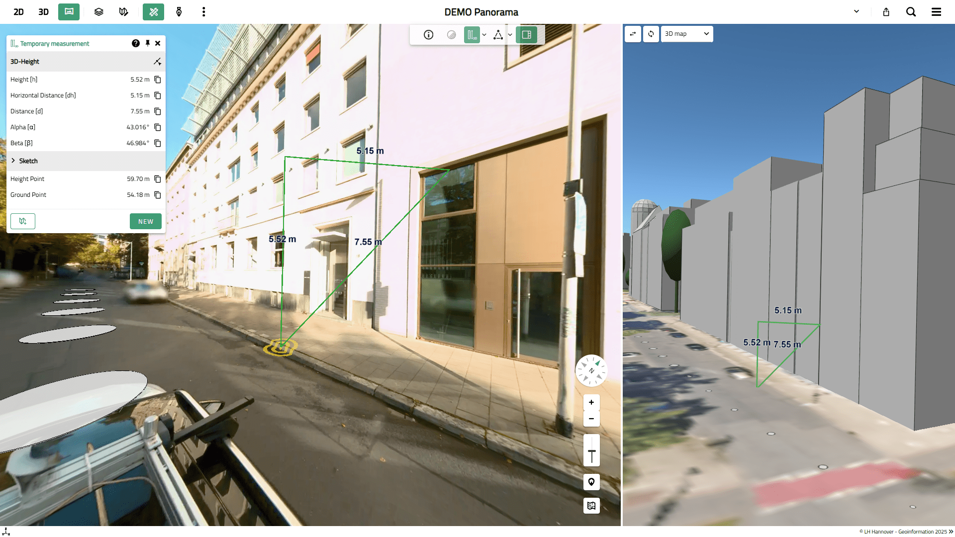
VC Panorama enables precise measurements and technical analyses directly within the panoramic image based on georeferenced 3D coordinates.
Requirements: In addition to panoramic images, depth information from point clouds generated during the survey must be available.
- Precise measurement of distances, heights, and objects using 3D coordinates
- Digitization and capture of objects in the panoramic image
- Use of associated depth and intensity information for technical assessments
- Integration of analysis results into the spatial context of the digital city model
VC Panorama Converter – integrate and manage survey data
The VC Panorama Converter, an extension of the VC Publisher, integrates, processes, and manages mobile mapping data and individual panoramas.
The converter adds a panorama task to the VC Publisher, which prepares and optimizes the input data—panoramic images, capture locations, and point clouds—for visualization. The VC Panorama Converter supports:
- the preparation of any panorama data for viewing in VC Map, provided the input data specifications are met
- the calculation of depth and intensity images for panoramas when a point cloud has been captured in parallel
- various vendors and camera systems, such as Trimble MX60, IGI StreetMapper, eagle eye technologies, Cyclomedia, etc.
Benefits of VC Panorama for users
VC Panorama extends digital city models with a realistic street-level view and supports well-informed professional assessments—without the need for additional site visits.
Particularly valued features include:
- Realistic assessment of street spaces in the context of the digital 3D city model
- The ability to visualize point cloud data and imagery simultaneously
- Efficient inventory capture and documentation without repeated site visits
- Time-saving workflows enabled by browser-based navigation and integrated measurement tools
- The ability to compare conditions across multiple survey periods
- Precise analysis based on georeferenced panoramic images with depth information derived from point clouds
- Vendor-independent use of existing mobile mapping data
- Consistent use of the same viewer—VC Map—regardless of the data acquisition provider
Openness and transparency in Virtual City Systems’ 360° Viewer
There are a wide variety of systems and providers for capturing panoramic images through mobile mapping surveys or at individual locations. These systems typically offer their own viewer solutions and use internal data structures to store and visualize the images and metadata, such as capture location, orientation, and timestamps. This makes it difficult to integrate data from different systems into a single application.
Virtual City Systems has released the viewer component of VC Panorama as open-source software as part of VC Map and has published the data specification for the integration and visualization of panoramic data in the VCS GitHub repository. Users of VC Map can utilize the panoramic image features by converting their own data into the appropriate viewing structure—regardless of whether they are customers or use the open-source version of VC Map.
Alternatively, the VC Panorama Converter is available as an add-on for VC Publisher customers. It converts data from street-level surveys or individual panoramas into the appropriate data structure, provided the input data specifications are met.
- Panoramic images as equirectangular images
- Metadata such as capture location, capture time, and orientation of the image data
- Optional: Point clouds from the survey, if depth maps are to be generated
VC Panorama in context of the VC Suite
The Panorama view is integrated into VC Map, and 360° panoramic images are displayed and analyzed here. The Panorama Converter, available as an add-on module for VC Publisher, handles the technical processing of the panoramic images. Alternatively, image conversion can be provided as a service.
VC Publisher Extension: VC Panorama Converter
Convert panoramic images into a usable format and prepare them for integration.
VC Map
View, locate, and analyze georeferenced 360° views in the digital city model.
Frequently asked questions about VC Panorama
VC Panorama is designed for local governments and organizations that plan, operate, or document roadways and infrastructure, particularly municipal departments, planning firms, and infrastructure operators.
VC Panorama leverages the open architecture of VC Map, which is available as open-source software. This means there is no lock-in to a proprietary system. Depending on the use case, VC Map can be deployed on-premises or via VC View.
Yes. VC Panorama can be integrated step by step into existing VC Map environments and deployed specifically for particular use cases. Thanks to VC Map’s open architecture, modular expansion is possible.
VC Panorama is suitable for visualizing both georeferenced panoramic images captured during road surveys and individual georeferenced panoramas. Panoramic images in equirectangular projection and metadata for each image (3D coordinates, timestamp, orientation values) are required. If measurement and analysis functions are to be used, additional depth information from point clouds is required. Read more about the input data specifications (PDF).
Yes. Measurements are possible if, in addition to the panoramic images, there is additional depth information available from point clouds. The measurement is performed directly within the panoramic image based on georeferenced 3D coordinates.
VC Panorama is an integral part of VC Map. It allows 360° images to be displayed in conjunction with 2D geodata, 3D geodata, and oblique aerial images. This is ideal for combining and aligning heterogeneous datasets.
VC Panorama thus supports measurements and analyses of panoramic images in the context of municipal geodata, regardless of whether these are purely 2D, 3D, or oblique aerial images. It is also ideal to link the panoramic images with the 3D visualization of point clouds from road surveys.
Integrated into the digital city model and enables the technical analysis, measurement, and evaluation of panoramic images in the context of municipal geodata. Unlike traditional Street View solutions, structured technical and geodata are available that can be directly integrated into planning and administrative processes.
No. VC Panorama supports traffic data from various providers and camera systems.
Regardless of the survey service provider, VC Map serves as a unified viewer. Thanks to the seamless integration of survey data and panoramic images into VC Map/VC Suite, all geodata can be viewed together in a single viewer. There is therefore no need for a separate viewer for panoramic images that is independent of VC Map.
Yes. It is browser-based and runs within VC Map, without the need for any additional client installation.
VC Panorama is a functional component of VC Map within the VC Suite. The images are displayed in VC Map, while the conversion of panoramic images can be performed for a fee using the VC Panorama Converter—an extension within VC Publisher—or as a service.
VC Panorama can be deployed either as an on-premises solution or via the SaaS solution VC View. The chosen deployment model determines how data storage and technical provisioning are organized.
In the field of panoramic images, there is no binding open standard established by a standardization body. Each manufacturer and solution provider decides independently which image formats, panoramic display methods, and metadata formats to use.
Virtual City Systems has decided to disclose the data specifications for viewing panoramic images in VCS. They are stored in the VCS GitHub repository.
The requirements for input data for the VC Panorama Converter are also documented and available for use.
The VC Panorama Converter is not part of VC Panorama’s visualization features; rather, it is used to prepare panoramic images for use in VC Map.
It can be purchased separately from Virtual City Systems and will then be available in VC Publisher. Alternatively, Virtual City Systems can provide the conversion of panoramic data as a service.
The data specification for viewing panoramic images in the VC Map is available in the VCS GitHub repository.
The input data requirements for the VC Panorama Converter are also documented and can be used.
Experience VC Panorama live
Would you like to see how 360° panoramic images can be integrated into your existing planning and management processes? We’d be happy to demonstrate VC Panorama using your specific use cases.

“What I find exciting about VC Panorama is that it allows real-world footage and a digital city model to be combined so seamlessly. This creates a much more accurate picture of what a situation actually looks like on the ground.”