Digital TwinSmart CityUrban Simulation
Urban Weather Forecasting for Bremen: Digital Predictions in the Urban Digital Twin
Urban Weather Forecast – Prototypical development of a climate service for high-resolution prediction of urban weather extremes
Content
In this DBU-funded research project, a web application is being developed to provide hyper-local weather forecasts for the city of Bremen – fully integrated into the Urban Digital Twin. Virtual City Systems (VCS) is responsible for the technological implementation of the platform, including sensor data integration, interfaces, and visualisation, in close cooperation with GEO-NET Umweltconsulting and the municipality of Bremen, and the Senator for Environment, Climate, and Science of the municipality of Bremen.
At a Glance
Project Funding
DBU – Deutsche Bundesstiftung Umwelt
Project Coordination
GEO-NET Umweltconsulting GmbH
Project Partners
- Stadtgemeinde Bremen
- Virtual City Systems (VCS)
Project Duration
Sept. 2025 – Aug. 2027
Objective
Development of a web-based urban weather forecasting system with a spatial resolution of 5 metres, integrated into the Urban Digital Twin
VCS Role
Platform development (VC Map), interface implementation, visualisation, integration of real-time and forecast data
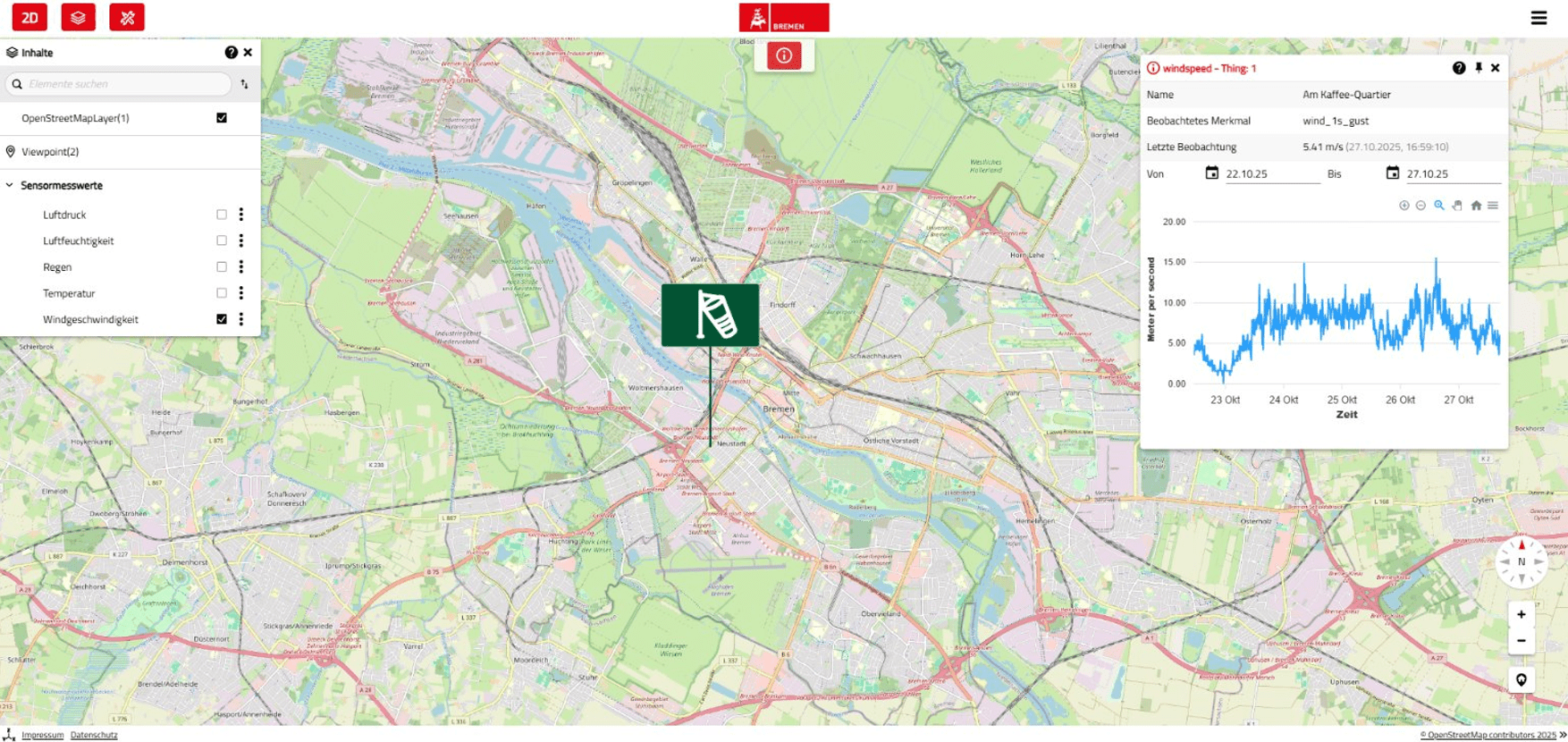
Visualised wind speed from the urban weather sensor network
About the Project
Why Cities Need Local Weather Data – And How Bremen Leads the Way
When heatwaves become a regular occurrence, strong winds strike specific neighbourhoods, and microclimates vary block by block, standard weather apps are no longer sufficient. Cities like Bremen face the challenge of adapting their urban structures to the effects of climate change — and need reliable, location-specific data to do so.
Together with the City of Bremen as the application partner, the project establishes a practical testbed: Bremen’s Urban Digital Twin is being extended to include dynamic weather forecasting. The results will feed directly into the city’s heat action plan and support local decision-makers in the fields of public health, infrastructure, and environmental protection.
The “Urban Weather Forecast” project delivers a scientifically grounded system capable of locating microscale weather phenomena in real time and providing accurate forecasts. The prototype is developed collaboratively by all project partners.
Technical Foundation: Urban Climate Models Meet Forecast Data in the Digital Twin
The application combines high-resolution urban climate modelling with numerical weather prediction models such as ICON — enhanced by live sensor data from the city. A “weather model library” containing pre-processed scenarios forms the basis for dynamic forecasting.
Integration is handled through standardised interfaces:
- timedependent WMS for linking forecast models
- SensorThings API for streaming real-time sensor data
- REST-based access for statistical climate data
This data is embedded in the VC Map-based web interface and visualised interactively. Users can explore time-series maps, conduct location-specific analyses, and — in the future — access animated 3D visualisations (based on NetCDF data).
VCS Technology for Urban Weather Forecasts: Interfaces, Visualisation, Platform
VCS contributes its extensive expertise in 3D city modelling and Urban Digital Twin development to implement the technical solution.
At the core of the project is the VC Map platform, which is extended with several key modules:
- integration of GEO-NET forecast models via OGC-compliant interfaces
- an enhanced IoT plugin for incorporating Bremen’s sensor network
- a REST API for spatial climate data queries
The visualisation of wind and temperature distribution in the 3D environment is also being expanded. Time-varying NetCDF datasets can thus be explored intuitively.
The interface and visualisation architecture are designed to be transferable to other cities with a compatible data infrastructure.
Urban Weather in Action: Supporting Climate Resilience for Cities and Citizens
The web application is not only aimed at technical departments, but also designed as a publicly accessible tool for the entire urban community. Care facilities and schools can respond more precisely to heat events, event organisers can assess local weather risks more reliably, and planners can evaluate new urban developments under climate-related criteria.
The experience in Bremen illustrates the practical value of locally resolved weather forecasts in municipal operations. With the anticipated increase in extreme weather events across Germany – including heatwaves, urban drought stress, and localised wind events – the demand for such digital climate services is expected to grow.
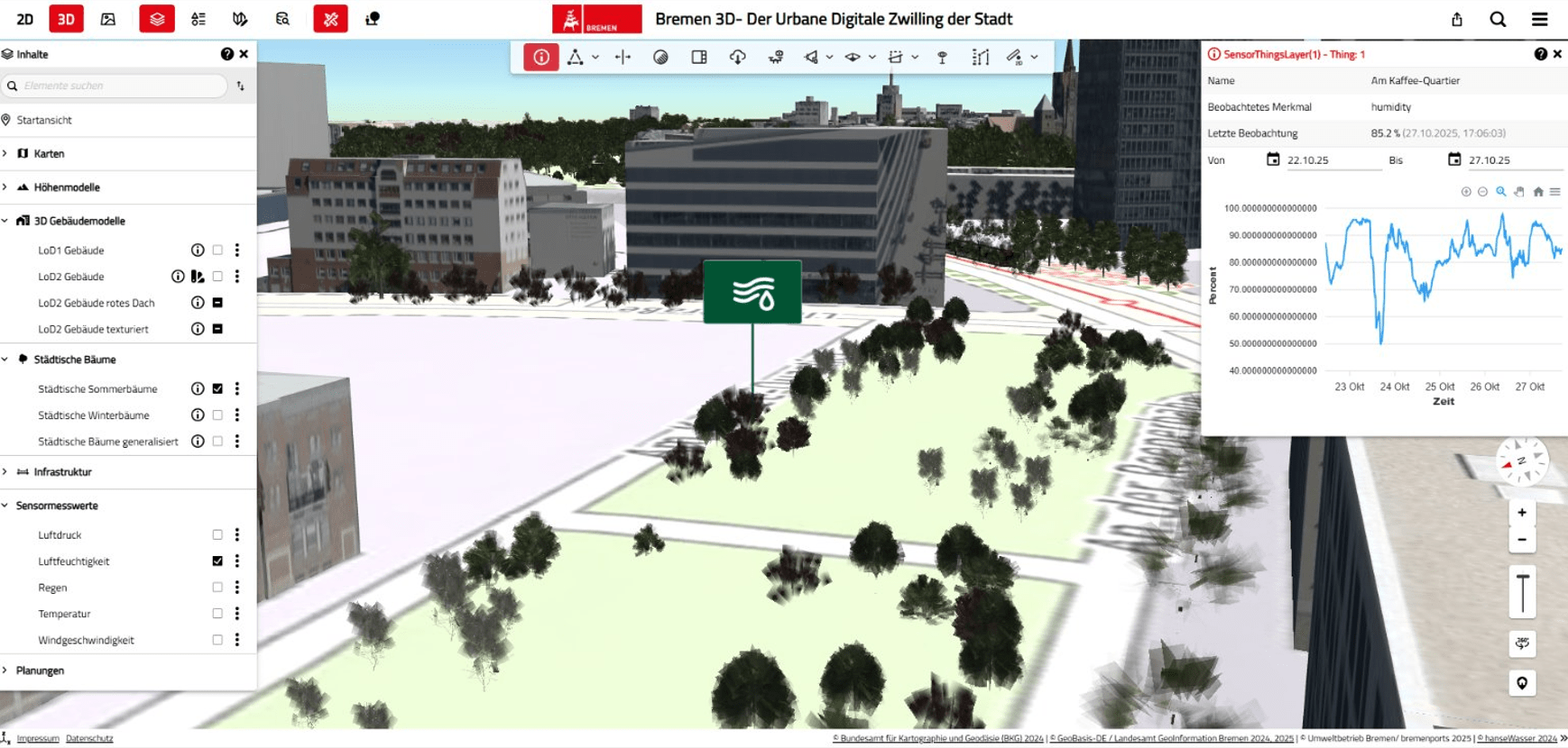
Time-based sensor data in the Urban Digital Twin
Scalable Climate Services: From Bremen to Other Cities
From the outset, the project has been designed for scalability. Thanks to standardised technologies, modular software architecture and the open framework of the Urban Digital Twin, the solution can be adapted by other municipalities.
VCS, in cooperation with GEO-NET, aims to bring the prototype to market readiness and explore broader implementation opportunities. The goal is to deliver a robust, interoperable system for local climate adaptation – technically sound, practice-oriented, and future-ready for new weather and climate data formats.