Smart CityUrbaner Digitaler ZwillingWebinar
Digital Twin Wiesbaden: How 30 Years of Geodata Evolved into a Central Smart City Platform
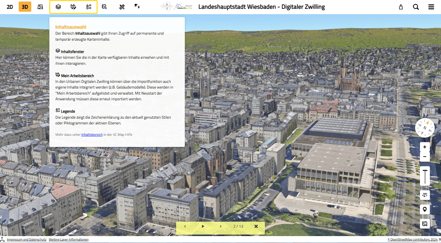
The Digital Twin of Wiesbaden is the result of 30 years of continuous data work. In the webinar on April 22, 2026, the City of Wiesbaden and Virtual City Systems demonstrated how decades of geodata development have grown into a central smart city platform for administration and the wider public.
A Digital Twin Doesn’t Happen Overnight
The roots of the project go back to the early 1990s, when Wiesbaden began maintaining its city base map in a fully digital, seamless format — a milestone that now seems self‑evident but laid the foundation for everything that followed. In the 2000s, orthophotos and the first 3D building models were added. Over time, the focus shifted: data should not only exist, but work together.
The decisive step came in 2025, when Wiesbaden published its Digital Twin for the first time. For the first time, data and specialist information were available in a single application — visible, connected and usable for both administration and the public.
Governance as the Foundation: Why Organization Matters More Than Technology
A Digital Twin is not created within a GIS team alone — it is created within the organization. Wiesbaden recognized early on that such a platform can only succeed if responsibilities and processes are clearly defined.
A steering committee made up of two municipal departments provides strategic direction. Beneath it, an interdisciplinary project team brings together expertise from surveying, smart city, civil engineering, communications, IT, legal affairs and data strategy. The project leadership is intentionally cross‑departmental — a structural signal that promotes collaboration and breaks down silos.
Municipal companies, public utilities, universities, as well as data protection and IT security officers are also closely involved. This broad setup is essential to ensure long‑term data quality and up‑to‑date information.
Data Quality at the Core: How Wiesbaden Integrates Its Data
At first glance, the technical foundation of the Digital Twin appears simple. In reality, it is built on a clearly structured data management approach that many municipalities still need to establish. Wiesbaden distinguishes three central data pathways, all running through the same infrastructure to ensure consistency.
Manually Maintained Specialist Data
Many datasets originate directly in the specialist departments—for example, information on childcare facilities, schools, construction sites or advisory services. They are maintained at the source, provided via standardized services and automatically integrated into the Digital Twin. This keeps them up to date without requiring manual intervention from the development team.
Automated Sensor Data
Real‑time data, such as parking garage occupancy, is updated every two minutes. It is processed via REST interfaces and stored in the same infrastructure as all other data. This creates a coherent picture that combines static and dynamic information.
External Data Imports
External partners often provide data in formats such as Excel. These datasets are transformed in FME, integrated into the city’s data model and then automatically published. Once connected, updates run without additional effort.
Together, these three pathways ensure that data—regardless of its origin—is available in the same structure, quality and level of timeliness. This is a fundamental requirement for any Digital Twin.
Practical Applications: Where the Digital Twin Creates Real Value
The Digital Twin of Wiesbaden demonstrates its value especially where data from different domains comes together. Three examples illustrate its potential.
Construction Sites: The Most Frequently Used Module
What is visualized?
- Current construction measures
- Duration
- Responsible authority
- Impact on mobility
Construction site information is among the most frequently accessed content.
Citizens can instantly see where construction is taking place, how long restrictions will last and who is responsible. The data comes from the civil engineering department and the traffic authority — and is centrally maintained for the first time.
Heat Planning: Making Complex Information Understandable
What is visualized?
- Heat demand density
- Potential analyses
- Target scenarios
Municipal heat planning is another example of how the Digital Twin makes complex information accessible. Heat demand, potential analyses and target scenarios can be viewed in spatial context. This turns abstract planning data into something tangible—enabling residents to understand developments in their own neighborhoods.
Culture & Social Services: All Information in One Place
What is visualized?
- Family services
- Childcare facilities, schools & school districts
- Libraries
- Cultural venues
In the social and cultural domain, the platform’s value becomes especially clear. Information on childcare, schools, school districts, advisory services or cultural venues — previously stored in separate systems — is now available in one place. This creates a genuine orientation tool for residents.
Interactive Storytelling: Making Urban Development Tangible
With interactive tours, camera flights and project explanations—such as those for World Design Capital 2026—urban development becomes visually accessible. This format will continue to grow, supporting topics such as city history, infrastructure projects or climate adaptation.
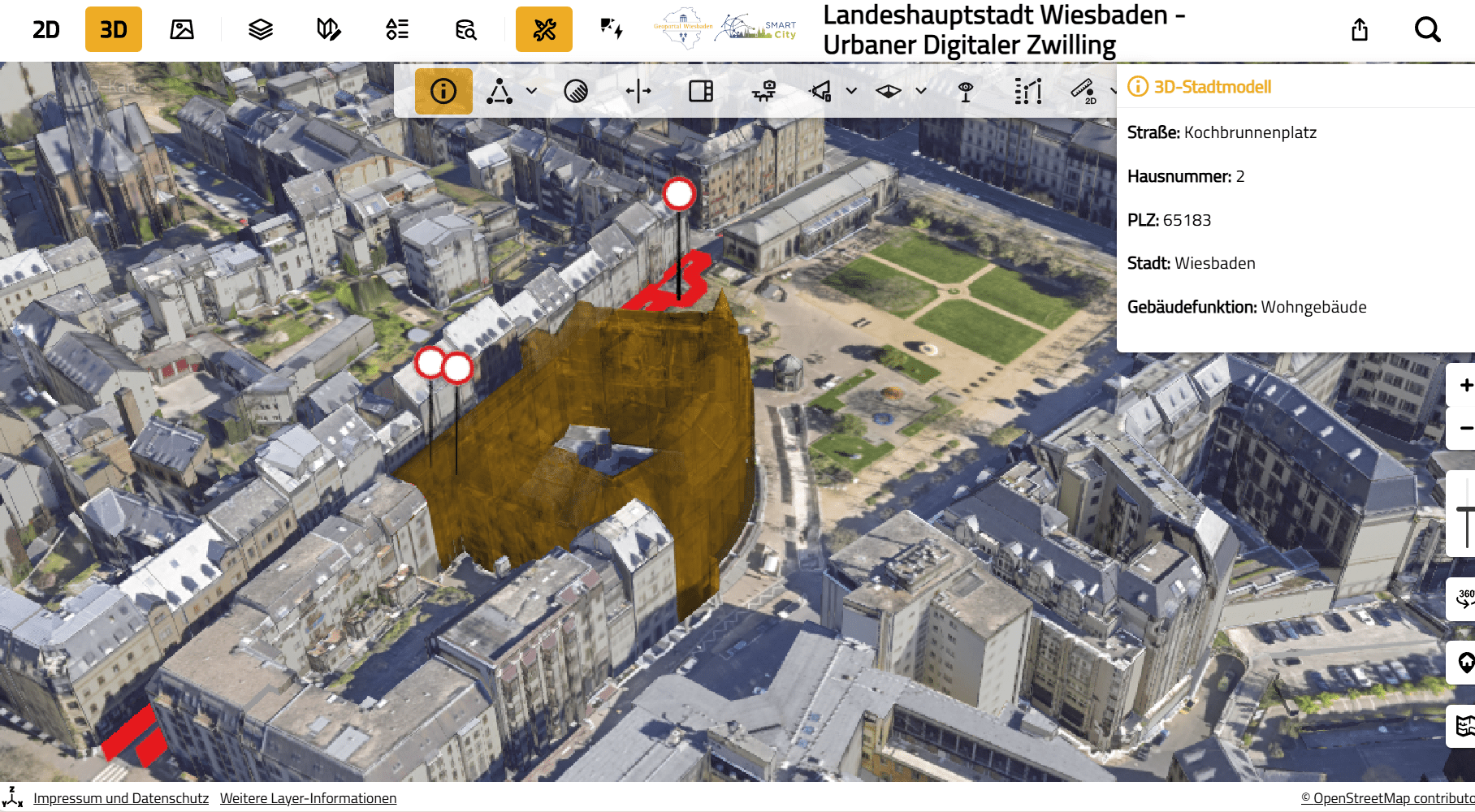
Construction sites in the city: Visualization of current measures with marked road closures and detailed information on location and building function.
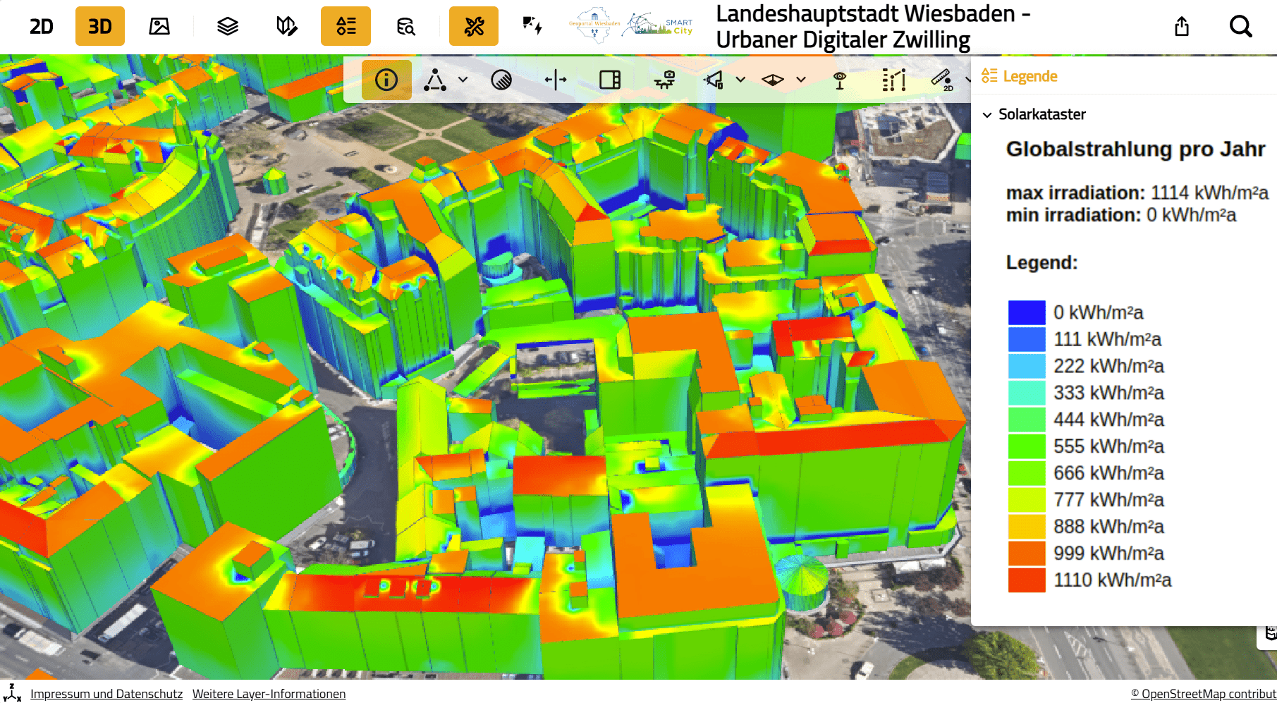
Solar potential analysis: Color‑coded representation of annual global solar irradiation per building based on Wiesbaden’s solar cadastre.
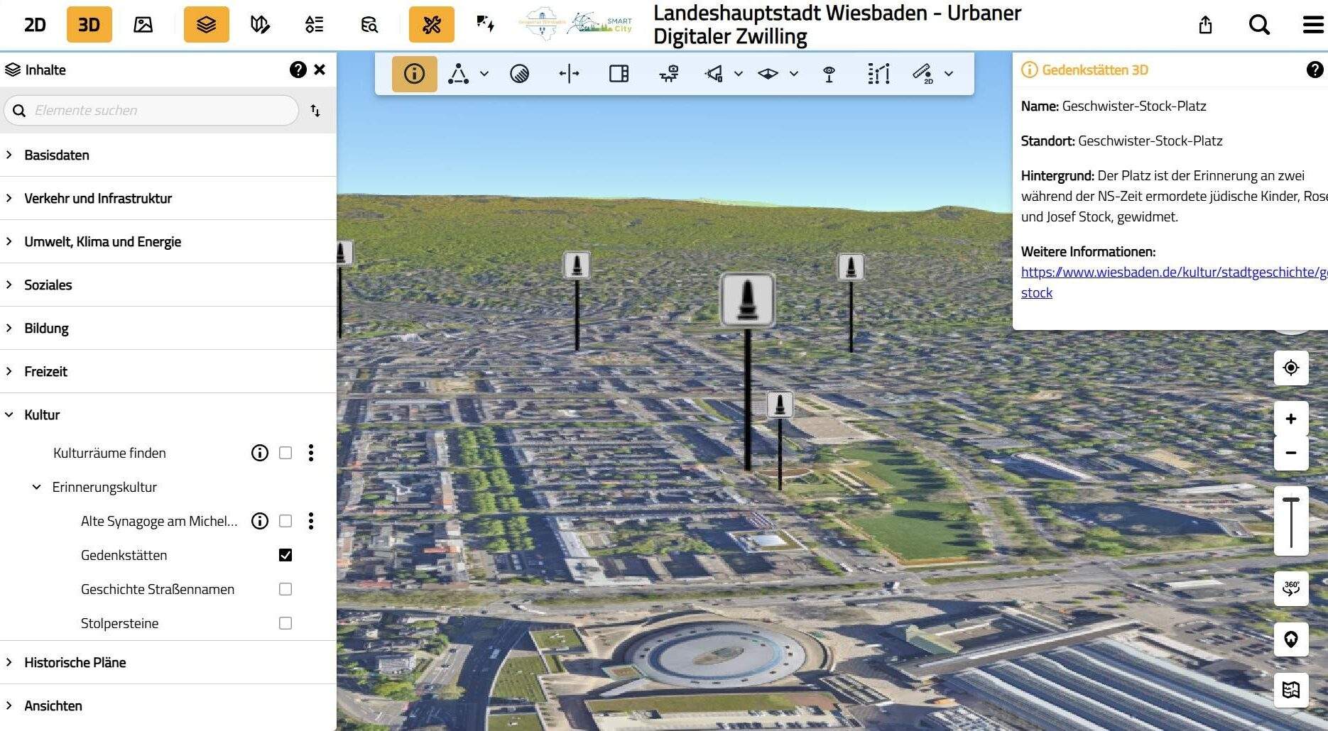
Cultural and memorial sites: Location information, background texts and further links directly within the Digital Twin.
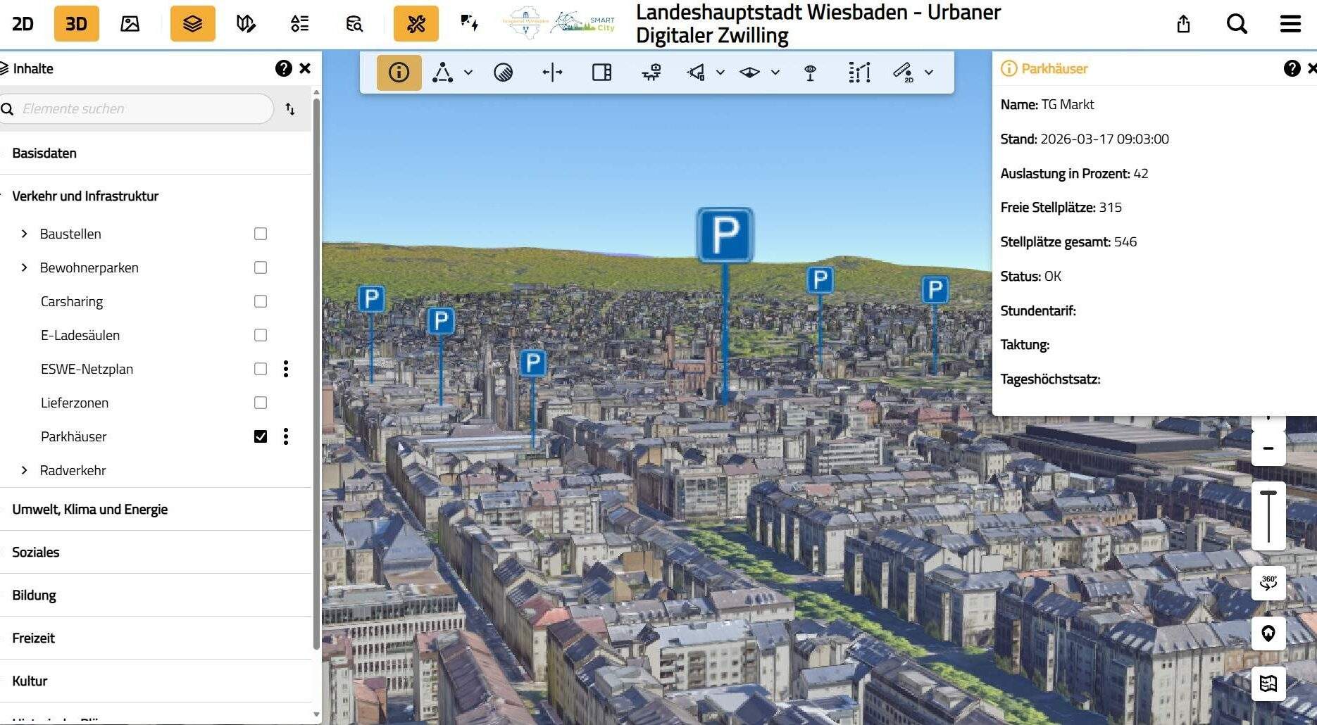
Real‑time parking occupancy: Display of free spaces, occupancy levels, tariffs and status information across the city.
3D city model: Interactive guided tour with thematic content and navigable scenes in the VC Map.
A Strategic Choice: Hosting or In‑House Infrastructure?
Many municipalities begin with hosted solutions because they are quick and straightforward. As usage grows, however, requirements change: data protection, integration with existing systems, automation and customization become increasingly important.
Both approaches are viable. The key question is how central the Digital Twin should become within the municipal IT landscape and how deeply it should be integrated. The open‑source approach of Virtual City Systems supports both directions: hosted environments for a fast start and in‑house operation for maximum integration depth.
The Roadmap: How the Digital Twin Will Continue to Evolve
Wiesbaden is currently developing an internal Digital Twin designed to handle sensitive data and specialist applications—for example, for disaster management. At the same time, the city is advancing the integration of open data to automatically incorporate datasets from the EU, federal and state levels, as well as the city’s own open data platform.
Interactive storytelling will also be expanded to visualize city history, infrastructure projects or climate adaptation. In the long term, simulations, scenario modeling and AI‑supported processes are planned. The city emphasizes that this is a 20‑ to 30‑year development horizon—realistic rather than visionary.
Q&A: Frequently Asked Questions from the Webinar
Updates are maintained directly within the specialist departments. Standardized services and interfaces ensure that changes automatically flow into the Digital Twin — without additional effort for the project team.
The public Digital Twin contains only data that can be published. A separate internal Digital Twin is being developed for sensitive information with restricted access.
The architecture is designed to connect new data sources quickly — whether manually maintained, automated or externally delivered.
Yes. CAD and specialist planning models can be incorporated and evaluated in spatial context, supporting coordination and decision‑making processes.
Conclusion: Wiesbaden Shows How a Digital Twin Truly Emerges
The Digital Twin of Wiesbaden is not an isolated tool but a municipal data platform built on three pillars: a long‑established geodata foundation, a clear governance structure and a technical architecture that ensures consistent data quality. It demonstrates how municipalities can evolve existing structures to gradually build a smart city platform that delivers real value — for administration, specialist departments and the public.
Interested in Learning More? If you are planning a Digital Twin or want to further develop existing systems, we are here to support you.

„Wiesbaden shows how partnership-based collaboration can produce solutions that also benefit other municipalities—through open architecture, reusability and joint forward thinking.“