Digital TwinPartnerSmart CityWebinar
Smart City in Rural Areas: How the Digital Twin in Hof Connects Data, Participation, and Planning
In the webinar “hoferLand.digital in conversation,” the Landkreis Hof (District of Hof), Virtual City Systems, DKSR, and RIWA demonstrated how to build an intermunicipal Smart City platform. At its core: the Digital Twin as a tool for planning, administration, and communication.
Smart City Project: 1 Platform for 27 Municipalities
On January 21, 2026, more than 170 participants attended the webinar “hoferLand.digital in conversation – A Model Smart City Project.” Hosted by Virtual City Systems in collaboration with Landkreis Hof, DKSR, and RIWA, the event focused on how a Digital Twin can be strategically developed, technically implemented, and practically applied in rural areas.
Participants were given insight into an open, modular platform that is usable across municipalities and integrates both spatial and real-time data.
Intermunicipal Data Infrastructure in Collaboration
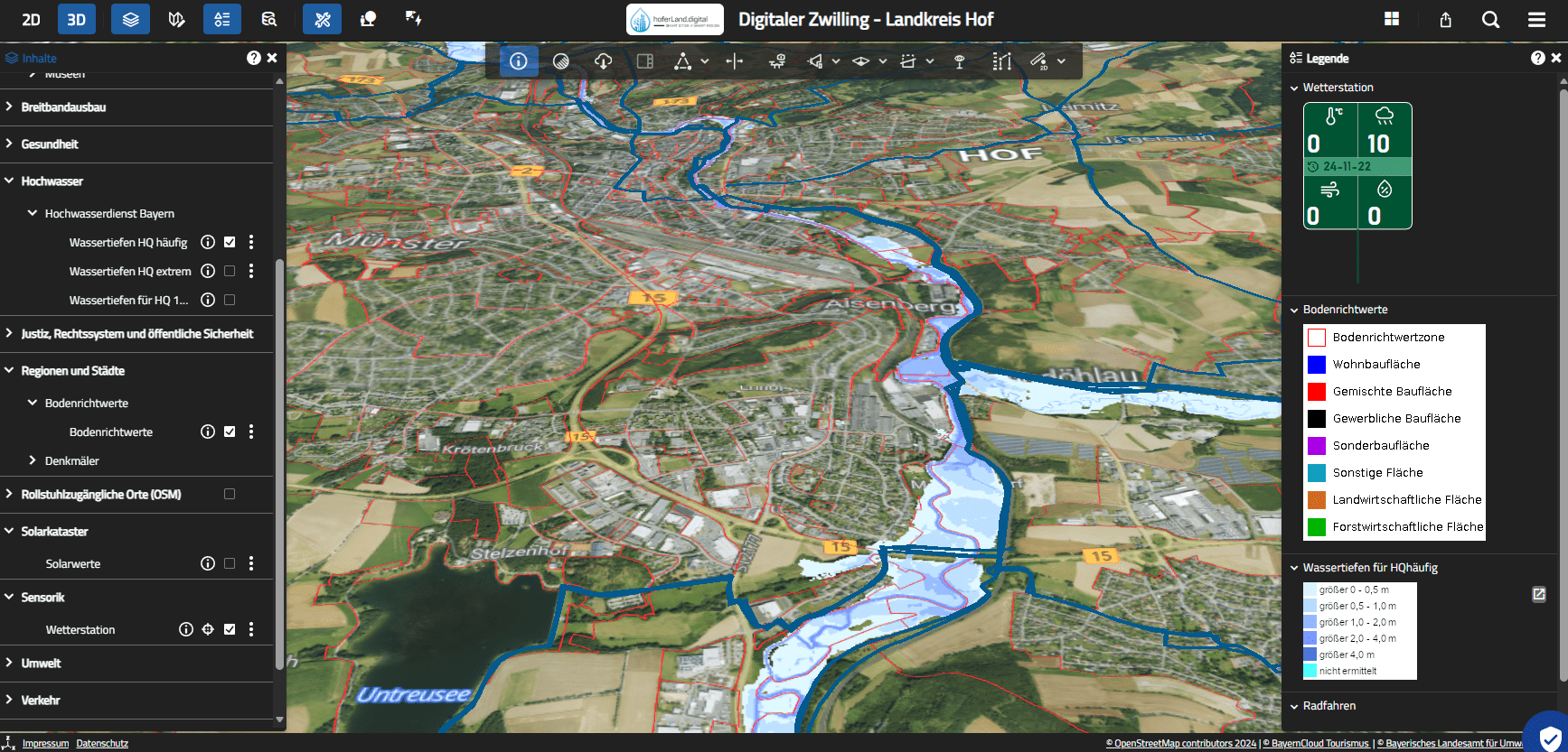
hoferLand.digital combines various technical modules into a connected infrastructure. At the center is the Digital Twin, which brings together data, applications, and user groups. The platform includes:
- Urban Data Platform (UDP): Structured data from multiple sources converge here, including real-time sensor data (LoRaWAN), statistical data, and information from specialist procedures. The UDP serves both as an operational tool and as a central data repository for analytical evaluations.
- Dashboards: Various departments access key figures and process information via dashboards. For example, the winter service uses live data on icy conditions – prepared for quick decisions and long-term optimization.
- Open Data Catalog: Selected data sources are made available as open datasets to promote transparency and reuse. The catalog supports both administration and civil society in data-driven decisions and projects.
- Digital Twin via VC Map: The cartographic component visualizes data spatially. 2D and 3D visualizations, shadow simulations, thematic map views, or custom planning overlays make complex interrelations tangible. Administration, policymakers, and the public all access the content – according to their permissions.
What makes it unique: all 27 municipalities in Landkreis Hof use the same infrastructure. This not only simplifies data usage and maintenance but enables seamless, intermunicipal collaboration in a digital space.
“We were able to combine the two existing geoportals into a new system. This means that all relevant data can be found clearly arranged in one place.”
— Alexander Kisler (Project staff „Smart Cities“, Landkreis Hof)
From Practice: Digital Applications with Direct Benefits
The live demo by Alexander Kisler (Landkreis Hof) clearly showed how concretely and user-oriented the Digital Twin is already in use:
3D Solar Potential
The integrated solar calculator uses 3D building models to calculate yield, costs, and area potential for any roof surface. Both municipalities and residents can use this information to make well-informed energy planning decisions.
Operational Planning with Ice Hazard Data
Over 130 sensors record ground and air temperature throughout the county via LoRaWAN. The data is visualized in a dashboard using traffic-light colors to indicate required action. The winter service saves resources and can coordinate its operations more efficiently.
Accessibility in Public Spaces
In collaboration with RIWA, an application was developed to assess locations based on wheelchair accessibility. The information is publicly available and supports both planning processes and everyday life for individuals with limited mobility.
Shadow Simulation in Planning Processes
In one specific case, the shadow impact of a proposed building near a childcare center was simulated. The result helped resolve concerns and secure the approval decision.
Visualization of education, health, flooding, broadband, and more – interactively in the Digital Twin
Technical Features with a Focus on Benefits
The implementation is based on a combination of standardization, modularity, and targeted integration:
- Seamless Interfaces to existing municipal GIS systems ensure that pre-existing geodata is integrated.
Benefit: No duplicate data maintenance, no isolated solutions. - Sensor Integration via LoRaWAN feeds real-time data directly into maps and dashboards.
Benefit: Immediate control advantages for technical services and operational planning. - Cataloging according to DECAT-AP Standard ensures that metadata is machine-readable, discoverable, and interoperable.
Benefit: Simplifies both open data usage and internal data management. - Thematic Map Navigation provides clear access to complex content.
Benefit: Users – from planning experts to council members – can reach relevant information with just a few clicks.
Co-Creating and Sharing Data Spaces
hoferLand.digital demonstrates that even rural regions can establish powerful Smart City structures. Intermunicipal collaboration, data reusability, and modular architecture make the project transferable and scalable. The Digital Twin is the central tool that meaningfully connects data, planning, and participation.